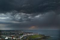
Storm Amy, the first named storm of the UK’s 2025/26 season, is set to unleash a barrage of severe weather across northern and western Britain in the coming days, with the Met Office warning of gale-force winds, torrential rain, and the potential for widespread disruption. As of October 1, 2025, meteorologists have sounded the alarm for communities in the path of a rapidly intensifying system, urging vigilance and preparation as Amy approaches.
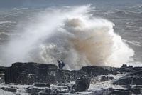
According to the Met Office, yellow warnings for wind and rain have been issued for much of Scotland, northern England, and Northern Ireland, effective from Friday evening through late Saturday. The agency forecasts that inland gusts could reach 60 to 70mph, while exposed coasts and hills may experience wind speeds exceeding 80mph—a level capable of causing structural damage, power outages, and even posing a danger to life from flying debris and large waves. "Gusts of 50 to 60mph are likely for many areas and may reach 60 to 70mph in some places for a time," the Met Office stated, adding, "Exposed coasts and hills will see the highest gusts which could exceed 80mph. The strongest winds currently look more likely over parts of northern Scotland."
Heavy rain is also a serious concern, particularly for western Scotland where forecasters predict 30 to 50mm of rainfall widely, with localized totals on high ground and in the northwest potentially reaching 60 to 80mm within a matter of hours. These downpours, the Met Office warns, could trigger local flooding and landslides, especially in areas already saturated by earlier rainfall. "The rain will turn heavier for a time during Thursday afternoon and evening, before clearing most areas by or soon after midnight," the agency explained. "Coming on top of rain that has already fallen in recent days, this is expected to lead to a risk of landslides as well as localised flooding."
Martin Thomson from Transport Scotland emphasized the likely knock-on effects for travel and infrastructure. "The rain and wind will bring difficult driving conditions, such as reduced visibility and surface water, and are also likely to affect the ferry and rail networks, so it's important to plan your journey ahead of time," he said, as cited by Sky News. He advised motorists to consult the Traffic Scotland website before setting out and to check with operators regarding the status of trains, ferries, and flights. Disruption to transport networks is expected, with high-sided vehicles and exposed routes in northern Scotland particularly at risk.
The evolution of Storm Amy is being closely watched by meteorologists, as its development has been influenced by the remnants of Atlantic hurricanes Humberto and Imelda. According to the Met Office, these former tropical cyclones have accelerated the jet stream, contributing to Amy’s rapid intensification as it barrels toward the UK. Tom Crabtree, the Met Office’s deputy chief meteorologist, noted, "Although there is still some uncertainty about the exact track Storm Amy will take, the system will bring gale-force winds across northern and western regions. Heavy rainfall is also expected, particularly over western Scotland, where totals could exceed 30-50mm in six to nine hours, increasing the risk of localised flooding." He added, "Forecasts and warnings will be updated as the situation becomes more clear, therefore it is important to keep an eye on the forecast for your area over the coming days."
The storm’s arrival marks the official start of the UK’s 2025/26 storm season, which began in early September. Each year, the Met Office, along with Ireland’s Met Éireann and the Netherlands’ KNMI, unveils a new alphabetical list of names for storms expected to have "medium" or "high" impacts. For this season, Amy leads the list, followed by Bram, Chandra, Dave, Eddie, Fionnuala, Gerard, Hannah, and Isla. Names are chosen from public submissions across the UK, Ireland, and the Netherlands, reflecting both popular and personal connections. For instance, Fionnuala was suggested by someone who wrote, "My daughter's name... Good strong name! What you'd expect from a storm," as reported by BBC News.
The practice of naming storms, introduced in the UK in 2015, aims to raise public awareness and aid communication during severe weather events. The Met Office’s Head of Situational Awareness, Will Lang, explained, "We do it because it works. Naming storms helps to make communication of severe weather easier and provides clarity." Surveys conducted after previous storms, such as Storm Floris, found that 93% of people in amber warning areas were aware of the alerts, and 83% took action to prepare—an indication that the naming system is boosting readiness and potentially saving lives.
Not all names make the cut, however. The list deliberately omits Q, U, X, Y, and Z, in line with World Meteorological Organization conventions and the difficulty of finding suitable names for every letter. The number of named storms varies from year to year: while the 2024/25 season saw six named storms, the previous year set a record with twelve. Sometimes, storms come in clusters, such as the three that struck in a single week in February 2022. The variability of the UK’s weather patterns makes forecasting a challenge, and the impact of climate change adds another layer of complexity. As Met Office scientist Emily Carlisle told BBC News, "There is some evidence that storms with strong winds (windstorms) will become slightly more frequent in the future in north-west Europe and also become more clustered, so that we experience several storms one after the other." She also noted that while it’s difficult to link individual storms directly to climate change, heavier rainfall and worsening coastal impacts from windstorms are expected as sea levels rise.
As Storm Amy approaches, communities across northern and western Britain are bracing for a turbulent start to the storm season. The Met Office and transport officials are urging residents to stay informed, heed warnings, and make preparations to minimize risk. With the storm’s path still subject to change, forecasters stress the importance of monitoring updates and remaining flexible with travel and outdoor plans. For now, all eyes are on Amy—a reminder of the power and unpredictability of the UK’s weather, and the ongoing efforts to keep the public safe in the face of nature’s fiercest moods.