Metro Detroit and Southeast Michigan are bracing for a notable shift in the weather this week, with a cool and pleasant start giving way to a surge of heat and humidity by midweek.
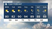
Monday, July 21, 2025, kicked off with refreshing conditions, thanks to a cold front that moved eastward over the weekend. High pressure built in behind that front, bringing northeast winds that ushered in less humid air and a cool start to the day. Temperatures hovered slightly below seasonal averages, with highs around 80 degrees, providing a welcome respite from the summer heat. According to FOX 2 Detroit, "This brings a shift to our wind direction, now coming out of the northeast. That means less humid conditions and cool starts to the day. High temperature today will be slightly below seasonal, around 80 degrees."
Tuesday, July 22, promises to be much the same, with sunshine, low humidity, and highs in the low 80s. As one local weather summary put it, "It's going to be a pretty perfect summer day with sunshine, low humidity, and highs in the upper 70s, near 80°. Tuesday will be just about the same, just a little warmer with highs in the low 80s." These comfortable conditions are ideal for those looking to enjoy the outdoors without the oppressive heat that often accompanies July in Michigan.
However, this pleasant weather won’t last long. The National Weather Service’s Detroit office forecasts a dramatic warming trend starting midweek. Temperatures are expected to climb sharply, reaching into the mid-90s by Wednesday, July 23, and Thursday, July 24. Meteorologist Keven Kacan explained, "Wednesday and Thursday will start to warm up quite a bit. Because it's going to be more humid, too, it could have heat indexes above 100 degrees Thursday." This means that while the thermometer might read in the 90s, the heat index — a measure that combines temperature and humidity to reflect perceived heat — could soar past 100 degrees, making conditions feel dangerously hot.
To put this in perspective, the average temperature for late July in this region is around 84 degrees. The forecasted highs represent a significant jump: about 5 degrees above normal on Wednesday and roughly 10 degrees above normal on Thursday. This sudden spike will bring back the tropical airmass that had retreated with the recent cold front, reintroducing high humidity levels that can make the heat feel even more oppressive.
FOX 2 Detroit highlighted the return of this tropical air, noting, "Of course, July in Michigan means it will get hotter and more humid. This will happen midweek with values rising to the 90s and high humidity levels returning. The heat index, (combination of high heat and humidity) could be around 100 degrees by Thursday. The tropical airmass will be with us through the end of the week with a chance for storms Friday and Saturday, so enjoy today." This warning underscores the importance of preparing for the upcoming heat wave, especially for vulnerable populations such as the elderly, young children, and those with health conditions.
The National Weather Service also anticipates some relief toward the weekend. AccuWeather forecasts scattered rain and thunderstorms on Friday, July 25, and Saturday, July 26, with temperatures cooling back down to the high 80s. This weekend weather pattern will likely be welcomed by residents who have endured the intense midweek heat. However, thunderstorms can bring their own hazards, including lightning, heavy rain, and localized flooding risks.
As the 4Warn Weather team advises, staying informed through local weather updates is crucial during such fluctuating conditions. Their July 21, 11 p.m. update reminds residents to keep an eye on changing weather alerts across Metro Detroit and Southeast Michigan, especially as the heat intensifies and storm chances increase.
In summary, Southeast Michigan’s weather this week is a tale of two halves: a cool, pleasant start with low humidity and moderate temperatures, followed by a sharp rise in heat and humidity midweek, pushing heat indexes above 100 degrees. The weekend promises some relief with cooler temperatures and rain chances, but not before the region experiences a significant heat surge that could challenge residents and infrastructure alike.
With summer in full swing, this weather pattern is a vivid reminder of Michigan’s variable climate — where a refreshing Monday can quickly turn into a sizzling Thursday. Whether you’re planning outdoor activities or simply trying to stay comfortable at home, it’s wise to prepare for the heat and heed local weather advisories as the week unfolds.