South Florida was battered by relentless stormy weather on Monday, June 2, 2025, as heavy rain, flooding, gusty winds, and lightning strikes swept across the region, causing widespread disruptions and prompting multiple weather advisories.
The day began with ominous skies and quickly escalated into a significant weather event. 7News cameras captured a dramatic lightning strike illuminating the Miami skyline, a vivid reminder of the power of the storm. Flood advisories and warnings were issued for all of Miami-Dade and Broward counties, signaling the severity of the situation and the potential dangers to residents and commuters alike.
Heavy downpours led to flooded streets and highways, notably impacting major thoroughfares such as Interstate-95 near 159th Street and Northeast and Northwest Second Avenue. The Florida Department of Transportation urged drivers to avoid the MacArthur Causeway, the vital link between Miami Beach and Miami, due to flooding on the ramps, especially as the afternoon rush hour approached. This flooding caused significant delays and forced motorists to seek alternate routes.
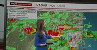
In northern Miami-Dade County, a flash flood warning remained in effect until 4:45 p.m., with Doppler radar detecting thunderstorms producing intense rainfall. Between 2 and 3 inches of rain had already fallen in some areas, with an additional 1 to 3 inches expected. Neighborhoods at risk included Hialeah, Miami Gardens, North Miami, North Miami Beach, Aventura, Opa-locka, Miami Shores, Golden Glades, Westview, Pinewood, West Little River, Ojus, and Biscayne Park.
Meanwhile, Broward County was not spared. The National Weather Service tracked a strong thunderstorm over Plantation moving northeast at 10 mph, expected to impact northern Broward through 2:45 p.m. Residents were warned about gusty winds capable of knocking down tree limbs and blowing unsecured objects, increasing the risk of damage and power outages.
Forecasters at the National Weather Service in Miami also issued alerts for communities farther south, from Doral down to Cutler Bay, warning of high winds reaching up to 50 mph, heavy rain, and even hail. Flooding was reported along Biscayne Boulevard between Northeast 11th and 13th streets, as well as on Northeast 13th Street from North Bayshore Drive to Northeast First Avenue.
Adding to the urgency, the National Weather Service's Storm Prediction Center designated a Level 1 out of 5 risk for severe weather across the Florida Peninsula on Monday, while the Weather Prediction Center posted a Level 2 out of 4 flash flood threat for South Florida on Monday and Tuesday. The threat was real and present, as meteorologists cautioned about the dangers of tropical afternoon thundershowers, which combine heavy rain, lightning, and strong winds.
"It's everything falling from the sky at that point," FOX Weather Meteorologist Michael Estime remarked, highlighting the intensity of the conditions. "It's hard to drive in those situations," added FOX Weather Meteorologist Craig Herrera, underscoring the hazards faced by commuters.
These stormy conditions are tied to a broader weather system developing over South Florida. The National Hurricane Center (NHC) is closely monitoring an area of low pressure fueled by tropical moisture from the Gulf of Mexico and the Caribbean. While currently possessing a low chance of tropical development over the next week, this system is expected to bring several days of heavy rainfall to Florida, with Miami, Fort Lauderdale, and West Palm Beach forecasted to receive 3 to 5 inches of rain by Friday, June 6.
NHC Director Michael Brennan explained on FOX Weather, "That's a pretty typical location for formation as we get into June. This is where we tend to see storms form in June, from the Gulf, across Florida, off the Southeast and mid-Atlantic coasts. So, it’s a great reminder that typically in June, those storms do tend to form pretty close to home, and people need to be ready and keep an eye out." He further noted that the low-pressure system is expected to stay over land or very close to the coast, which could limit its organization early on. However, if it moves off the southeastern U.S. coast, there is a possibility it could develop some tropical characteristics.
The arrival of more tropical moisture later in the week is expected to prolong the stormy weather, with thunderstorms predicted on Thursday, June 5, and Friday, June 6. This rainfall is a silver lining for the Sunshine State, as it should help alleviate ongoing drought conditions that have persisted through the dry season.
Authorities and meteorologists alike are urging residents to remain vigilant and prepared. The combination of heavy rain, flooding, and gusty winds poses significant risks, from hazardous driving conditions to property damage. As the storms continue to unfold, officials emphasize the importance of heeding warnings and staying indoors when possible.
While the storms have caused immediate inconveniences and dangers, the expected drier conditions later in the week, aided by the arrival of Saharan dust, offer hope for a return to more stable weather. For now, South Florida remains under the grip of intense weather, a reminder of the region's vulnerability during the early days of hurricane season.