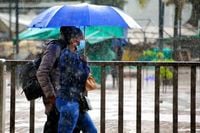
South Africa is bracing for a powerful and disruptive weather system this week, as a cut-off low pressure system moves across the country, triggering heavy rainfall, plummeting temperatures, snowfalls, and the risk of flash floods. According to the South African Weather Service (SAWS), the weather system is set to make landfall over the western interior on Wednesday, April 23, and gradually track eastward until Saturday, April 26, 2025. As it moves, widespread showers and thunderstorms are expected to impact much of the central and eastern regions, with some areas experiencing over 50mm of rain in just 24 hours.
“Many areas are already waterlogged and flooded, and with more rain expected the risk of flash flooding remains high,” warned Michelle du Plessis, meteorologist at Vox Weather.
Just over a month after a devastating storm hit Pretoria in February — and shortly after wildfires raged in Cape Town — the City of Tshwane and City of Johannesburg metros are once again on high alert. This comes as SAWS issues a Yellow Level 3 warning for severe thunderstorms expected over parts of Gauteng. Emergency services departments in both cities are on standby, monitoring developments closely.
According to SAWS, there is a 60%–80% chance of rain in Tshwane, and severe thunderstorms are expected from 11am until midnight on Wednesday. The storms could bring intense downpours, hail, strong winds and localized flooding.
Cut-off lows are potent weather systems that often form during seasonal transitions like autumn or spring. Characterized by upper air troughs that disconnect from the main flow and operate independently, every year in South Africa, these systems bring severe weather conditions and heavy rainfall, often leading to flooding, devastation, and destruction of economic activities.
The Free State and North West provinces are especially vulnerable, with forecasts predicting severe thunderstorms, hail, and flooding. SAWS has issued a Yellow Level 4 warning for disruptive rainfall over large parts of the country. “Flooding of roads and settlements, and damage to infrastructure, vehicles, and livestock are possible,” SAWS warned.
Heavy rainfall will persist along the east coast – especially in KwaZulu-Natal and the Wild Coast – until Saturday, while parts of the Gauteng, Highveld, and Bushveld regions will also receive significant rainfall.
Temperatures are expected to drop sharply midweek, resulting in snowfall across the Drakensberg mountains in Lesotho, KwaZulu-Natal, and the Eastern Cape. “Freezing levels have dropped significantly,” Vox Weather reported, with up to 15cm of snow expected in central and eastern Lesotho, and more than 20cm around Afriski.
Lehlohonolo Thobela, SAWS forecaster, explained, “That’s why you will start seeing snow over the high-lying areas of the Drakensberg mountains into KwaZulu-Natal, as well as the extreme eastern parts of the Eastern Cape into Lesotho.”
While cut-off lows are a regular part of South Africa’s autumn weather patterns, meteorologists are noting an unusually wet season. “This year has been unusually wet across many parts of South Africa,” Du Plessis noted, citing the influence of a weaker La Niña phase.
Though the El Niño-Southern Oscillation (ENSO) is currently neutral, local systems and tropical influences are playing a stronger role in recent weather events. Professor Guy Midgley of Stellenbosch University’s School for Climate Studies stressed that “every aspect of weather is altered in some way” by climate change. “The atmosphere and oceans are now much warmer than even 10 years ago,” he said. “We need to learn from these extreme events very fast if we are to adapt to these changes,” Midgley added.
SAWS is urging the public to avoid flooded roads and low-lying areas, stay indoors during heavy rain or thunderstorms, move valuables, vehicles, and livestock to higher ground, secure outdoor items, and monitor weather updates. Emergency services remain on standby, and residents are advised to download the WeatherSmart App or follow SAWS on social media for real-time alerts.
As storms gather across the country, South Africans are urged to stay vigilant and prioritize safety. The public is advised to monitor updates from SAWS via social media or the WeatherSmart app, and to avoid travelling during severe weather alerts unless necessary. For real-time updates, follow SAWS on X, Facebook, or download its WeatherSmart App from your app store.
In summary, a powerful cut-off low weather system is set to hit South Africa from April 23 to April 26, bringing widespread rain, cold temperatures, and severe storms, particularly in the Free State and North West. The South African Weather Service has issued a Yellow Level 4 warning for disruptive rainfall, predicting over 50mm in some areas. Snowfall is expected in the Drakensberg mountains, with up to 15cm forecasted for central and eastern Lesotho, as temperatures plunge midweek. Residents in affected areas are urged to take precautions, including avoiding flooded roads and securing valuables, while disaster management teams remain on high alert.