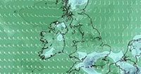
As the UK basks in recent sunshine, a surprising weather shift looms on the horizon, suggesting that snow could return by the end of March. Weather maps generated on March 19 by WXCharts indicate that temperatures may plummet to 0°C on March 29, with potential snowfall forecast for southern areas as far down as Hampshire and Southampton.
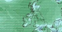
Despite the current warm spell, which has seen temperatures hover around 20°C in some regions, a significant drop is expected in the coming weeks. Areas such as Birmingham, Leeds, and Manchester are predicted to experience rainfall rather than snow, as forecasters indicate a chilly start to April.
While Thursday, March 20, 2025, is set to showcase a high temperature of 19°C in Manchester, weather conditions will soon shift. The Met Office has flagged a 45 percent chance of rain on Friday, March 21, with that likelihood increasing to 90 percent on Saturday, March 22, when temperatures will fall to around 14°C.
Nick Finnis, a meteorologist with Netweather.tv, provided insights into the impending weather changes, stating in his blog, "After a dry weekend and much of this week too, it’s likely to turn more unsettled from the south during Friday, as a new area of low pressure swings in from the Atlantic towards northwest Iberia on Friday, then extends northwards across the west of the British Isles over the weekend as quite a complex system with more than one circulation."
He continued to explain the incoming system, saying, "The low pressure system moving up from the southwest into the weekend will throw weather fronts north - bringing showery rain north across the UK from Friday afternoon, after a dry start. Further showers are moving or developing northwards over the weekend too, perhaps thundery in the south, but with some drier and brighter or perhaps sunny interludes in between. It will be much milder than of late though."
The Met Office’s long-range forecast for the period between March 24 and April 2 predicts an unsettled outlook, particularly for the southern regions of the UK. They noted potential heavy showers, especially on Sunday, March 23. "Still rather unsettled across much of the UK at first, with scope for some heavy showers across parts of the south on Sunday, but overall, the final week or so of March to the start of April looks to be characterized by a slowly evolving, generally changeable weather pattern," the forecast details.
In a more extended look at conditions from April 3 to April 17, the Met Office highlighted a lack of confidence in predictions but noted that blocked or slow-moving weather patterns are likely. This could result in either extended periods of dry weather or wetter conditions depending on the movement of weather systems across the UK.
Regarding the immediate forecast, Thursday is described by the Met Office as "a dry day with plenty of sunshine after early frost and any fog clears," while Friday will be a "bright and breezy day for many, with some warm sunshine, though showers developing in the southwest, turning cooler and more widely showery for the weekend."
The peculiarities of British spring weather often catch residents off guard, with this latest forecast serving as a reminder of the unpredictability inherent in weather patterns. Despite the promise of warmer weather earlier in the month, the prospect of snow returning is a stark contrast as temperatures shift.
With conditions rapidly changing, many are left to wonder how the shift will affect plans as March draws to a close. For those in Manchester and similar areas expecting rain, it’s advisable to prepare for a wet weekend ahead, while those in southern regions should keep their eyes peeled for unexpected snowfall.
In short, while the early days of spring have brought sunshine and warmer temperatures to much of the UK, the end of the month could turn dramatically colder. As weather conditions evolve, some regions will embrace the chilled air and potential snowfall, while others will remain resilient in the wake of impending rain.