Wausau, Wis. — A winter storm warning has been issued for Marathon County, including Wausau, from 1 p.m. Wednesday through 1 a.m. Thursday, according to the National Weather Service. Forecasters anticipate heavy snowfall mixed with sleet, totaling between 4 and 8 inches. Winds gusting as high as 40 mph could significantly reduce visibility and create hazardous driving conditions, particularly during the Wednesday evening commute.
The weight of heavy snow combined with strong winds may also bring down tree limbs and power lines, potentially causing sporadic power outages. "The weight of heavy snow combined with strong winds may bring down tree limbs and power lines, potentially causing sporadic power outages," said a spokesperson from the National Weather Service.
As residents in Mariano County prepare for these severe weather conditions, they are urged to avoid unnecessary travel. If travel is essential, it’s advised to keep an emergency kit including a flashlight, food, water, and warm clothing in their vehicles. Drivers can check current road conditions by calling 511. Additionally, residents are reminded to never approach or touch downed power lines and to report any outages directly to their electric company.
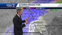
Meanwhile, in Omaha, Nebraska, a blizzard warning is in effect for the area on the same day. A wild week of weather is unfolding as the city transitions from unseasonably warm temperatures in the 70s on Tuesday to potential blizzard conditions by Wednesday morning. Isolated storms with hail are expected to occur tonight before rain transitions to snow as temperatures drop. The forecast shows wind gusts between 40 and 50 miles per hour throughout the day on Wednesday, leading to blizzard conditions.
“Blizzard conditions are likely for the rest of Wednesday, March 19, 2025, with heavy, wet snow and wind gusts up to 60 miles per hour,” reported the KETV weather team. This storm is projected to significantly impact the morning and evening commutes as snow accumulates.
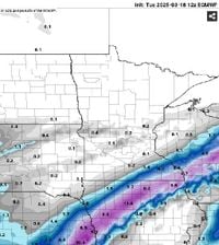
To the north, the Twin Cities in Minnesota are seeing a shift in storm predictions. Previous forecasts that warned of heavy snow in the area have now been downgraded. Winter storm warnings were dropped for the greater Twin Cities, though blizzard warnings remain in effect for much of southern Minnesota. The bulk of heavy snow is now expected to fall across northern Iowa, southeast Minnesota, and central Wisconsin.
The changing forecasts reflect a storm system that includes snowfall rates of 1 to 2 inches per hour developing Wednesday morning and lasting into early Wednesday afternoon. Northwest winds of 30 to 40 mph will accompany the snow, causing additional travel challenges.
"Snowfall rates of 1 to 2 inches per hour will develop Wednesday morning and last into early Wednesday afternoon," as stated in a recent weather advisory, underscoring the serious nature of the conditions residents will face.
As these conditions set in, residents across affected areas should remain vigilant and prepared for disruptions. The expected power outages and treacherous travel conditions create a significant risk for those on the roads. Authorities continue to emphasize the need for caution and preparedness.
Despite the challenging winter weather, forecasts predict that warmer temperatures are on the way later this week, with highs in the 40s ensuring a quick melt following the storms. This offers a glimmer of hope for residents once this severe winter weather passes, signaling that spring is indeed around the corner.