A winter storm has gripped the central United States, leaving a trail of disruption, power outages, and dangerous travel conditions across several states, including Nebraska, Colorado, and New Hampshire. As the storm system evolves, officials are closely monitoring the situation, aiming to mitigate impacts on communities and infrastructure.
Nebraska has been particularly hard hit. Governor Jim Pillen declared a state of emergency on March 21, 2025, for over 20 counties affected by the blizzard, which has caused road closures and significant damage to trees and power lines. Interstate 80 was among the major roadways shut down due to unsafe driving conditions. The storm resulted in a massive power outage, peaking at 119,199 customers without electricity on March 20, 2025, according to the U.S. Department of Energy. Although this number has considerably dropped to just over 29,000, the total damages are expected to exceed $21 million. Governor Pillen stated, “From state troopers who assisted stranded motorists to snow removal crews and now those involved in repairing downed lines to re-establish our power grid – a lot of people have stepped up very quickly to ensure that our safety has been the number one priority.”
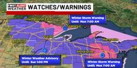
As the storm progresses, other states are preparing for their share of winter weather. Colorado is bracing for a storm expected to deliver snowfall of between 6 and 14 inches between midnight Friday, March 21, and midnight Saturday, March 22. Areas in Summit, Grand, and Eagle counties are under winter weather advisories due to expected heavy snowfall and strong winds. Joel Gratz, founder of OpenSnow, indicated that the northern and central mountains are predicted to receive 4 to 10 inches of accumulation, while lower elevations west of the Continental Divide might not receive substantial snow. The storm is expected to taper off by Sunday, but conditions will remain volatile, with the potential for snow returning next weekend.
Meanwhile, in New Hampshire, a lighter but pervasive wintry mix is anticipated early next week. Light snow and rain are expected on March 24, with snow forecasted to change over to rain in southern areas as temperatures rise. Meteorologist Matt Hoenig noted that patches of snow could lead to slippery travel conditions, primarily in the northern regions where 1 to 3 inches of snow accumulations are possible. High winds could gust up to 40 mph on Sunday, exacerbating hazardous conditions and reminding residents to remain vigilant during this transitional winter period.
Back in Colorado, landscape companies are gearing up for extensive snow removal efforts. Nicole Stone from LMI Colorado explained that preparations start well in advance, from checking equipment to coordinating with crews. “When storms move in during rush hour, that also puts our teams in rush hour, which delays response time,” she said. The combination of heavy snow and relentless winds creates challenges in both response time and in maintaining safe roadways.
The scenario isn't just confined to these three states. As storm systems from Colorado travel eastward, other regions may also experience snow. For instance, a low-pressure system developing between Alberta and Colorado is expected to bring moderate, sloppy snowfall, with forecast chances near 90% on March 23 and 24.
While some may see joy in the late snow, many residents are feeling worn down by the endless winter. “People are getting tired of this,” Gratz acknowledged. The impact on water supply and snowpack levels continues to be a concern as many areas remain behind the 30-year median snowfall.
In the wake of the winter storm, officials stress the significance of staying informed and prepared. “We encourage residents to stay updated with the latest weather advisories and to avoid travel unless it's necessary,” stated officials from various state emergency management agencies.
As the winter weather continues to affect vast portions of the country, communities are reminded to remain alert, heed warnings, and prioritize safety amidst the challenges winter storms bring. The hope is that with each passing system, a transition to warmer conditions is on the horizon for many regions waiting for spring to truly spring forth.