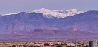
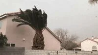
Strong winds and dropped temperatures swept through southern Nevada as the National Weather Service issued warnings for the Las Vegas Valley and surrounding areas. A low pressure system affecting the region on March 17 and 18, 2025, is anticipated to bring hazardous weather including gusts reaching over 60 mph and drastic drops in temperature.
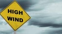
Weather advisories are currently active across multiple regions—specifically for the Mojave Desert, southern Nevada, and Death Valley National Park, highlighting potential travel disruptions due to the strong winds. The NWS reported, "A low pressure system will move through the area today and tomorrow, bringing strong winds with it and leaving below-normal temperatures in its wake." These winds are not just brisk but severe, predicted to exceed 40 mph across key areas, with gusts potentially reaching or surpassing 58 mph, particularly affecting the Owens Valley and Las Vegas Valley.
High Wind Warnings have been put in place for regions including the Eastern Sierra and the Spring Mountains. Morning forecasts predicted west winds of 25 to 35 mph, with gusts anticipated up to 60 mph, posing considerable risks for vehicle operators, especially for high-profile vehicles like trucks.
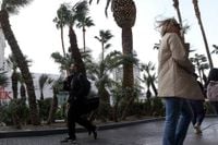
The NWS also indicated possible impacts from these weather patterns including travel hazards from strong crosswinds, reduced visibility due to blowing dust, and potential power outages caused by downed power lines. Residents were advised to secure outdoor items and remain cautious on roads where sudden gusts could destabilize vehicles.
For the mountain regions, conditions could deteriorate rapidly. A brief cold front moving through the area will likely lead to light snow accumulation, with snowfall expected to start at elevated levels around 7,000 feet dropping to around 4,000 to 5,000 feet. While some areas might see minor snow accumulations, the NWS does not foresee enough precipitation to warrant Winter Weather Advisories at this stage.
By the afternoon and evening of March 17, Las Vegas Valley and other nearby regions can expect sustained winds dropping to 20-30 mph, with gusts still holding strong between 40 and 60 mph. This could lead to worsening travel conditions especially as evening falls and the sun sets.
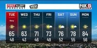
Looking toward the immediate forecast, the winds are expected to lessening somewhat post-March 18, coinciding with temperature recovery as high pressure builds over the region. Highs for March 18 are expected to dip to the mid-60s, but with gradual warming projected to return to the low-to-mid 70s by the end of the week as the region transitions back to calmer weather patterns.
For aviation operations, gusts approaching 40 knots are anticipated at Harry Reid International Airport, posing risk for severe turbulence due to possible mountain waves. The weather service noted, "A slight decrease in wind speed is expected after midnight," giving temporary respite to affected areas.
Overall, it is typical for this time of year to experience such fluctuations as the region approaches the spring equinox, which is set to occur on March 20, 2025. The variable weather next week points toward calmer conditions and clearer skies, making way for warming days more characteristic of the season.
Weather officers advise communities to stay vigilant and prepared as they navigate the latter half of March, where expectations of pleasant springs days need to be balanced with potential fierce winds and unpredictability associated with changing weather fronts.
With safety as the foremost concern, local meteorologists continue to monitor weather patterns closely, urging residents to stay informed via local updates and heed warnings issued by the NWS.