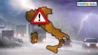
As Italy braces for severe weather conditions, a Mediterranean cyclone is set to unleash heavy rain and thunderstorms across the northern regions, particularly Piemonte and Valle d'Aosta. The storm, which began impacting the country on April 16, 2025, is expected to intensify through April 17, bringing with it the risk of flash floods and significant rainfall accumulation.
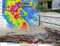
According to reports from Centro Meteo Italiano, the cyclone has already resulted in a deep depression forming over the central-western Mediterranean Sea. This system is projected to deliver intense rain and thunderstorms, particularly in the northwestern provinces of Torino, Biella, Vercelli, and Verbano Cusio Ossola. Residents in these areas are warned to prepare for the possibility of up to 400 mm of rain within just 48 hours, which is equivalent to 400 liters per square meter. Such extreme precipitation could lead to local flooding and flash floods, especially along secondary streams that may already be overwhelmed due to saturated soils.
The Civil Protection has issued a RED alert for adverse weather conditions, urging maximum attention and caution among residents. The term "flash flood" is being used to describe the potential for rapid flooding events resulting from intense rainfall, which can accumulate in short periods, causing dangerous conditions.
As the cyclone continues to move through Italy, heavy and persistent rainfall is expected to transform into snowfall at higher altitudes, particularly above 1400-1600 meters. This phenomenon will create winter-like conditions in the alpine and pre-alpine regions, despite the fact that it is already mid-April.
On April 17, the weather will remain unstable, with rain and showers also affecting central regions, including Toscana, Umbria, Lazio, and parts of the Marche. The southern peninsula, particularly Campania and the Tyrrhenian coast of Calabria, will experience compact cloud cover, intermittent rain, and potential thunderstorms. Meanwhile, the islands of Sardegna and the rest of the southern regions will see a mix of unstable weather with occasional sunny breaks.
As the weekend approaches, a brief respite from the rain is anticipated, thanks to a small anticyclonic promontory that is expected to provide a dry period on April 19 and 20. However, the calm will be short-lived, as another depression is forecasted to move over western Europe towards the Mediterranean on Easter Sunday, April 20. This could lead to renewed bad weather in the northwest, with rain expected to reach regions like Toscana and Sardegna by the afternoon.
On Easter Monday, April 21, the depression is expected to weaken, but unstable weather with rain and thunderstorms will still be prevalent, particularly in central and southern Italy. The outlook for the following week indicates that unstable weather conditions will persist in the central Mediterranean, with no significant signs of high pressure returning to stabilize the weather.
In summary, the upcoming days will be characterized by significant weather fluctuations across Italy. From heavy rain and snow in the north to more variable conditions in the south, the situation remains dynamic. Meteorologists are closely monitoring the developments and will continue to provide updates as the storm system progresses. Residents are advised to stay informed and take precautions as necessary.
For more information and updates on the evolving weather situation, follow Centro Meteo Italiano and other local meteorological services.