As severe weather looms across various regions of the United States, residents are advised to remain vigilant as multiple storm systems are expected to bring heavy rain, damaging winds, and the potential for tornadoes.
On Monday, March 31, 2025, a Severe Thunderstorm Watch was issued for the Grand Strand, Pee Dee, and Border Belt regions of South Carolina from 4 p.m. to 10 p.m. The Storm Prediction Center has categorized the risk for severe weather in the Pee Dee and Border Belt as a level 3 out of 5, indicating an Enhanced Risk. Meanwhile, the risk for Horry and Georgetown counties has been slightly downgraded.
Originally, the area faced a 10% chance of tornadoes on Sunday, March 30, but this risk has decreased to 2% as of Monday afternoon. Although this represents a low risk, officials still urge residents to take precautions. The primary severe weather threat on Monday evening is expected to be damaging wind gusts, which could potentially uproot trees. Additionally, there is a possibility of hail reaching up to the size of quarters within the strongest storms.
According to the forecast, the line of storms is likely to sweep through Scotland, Robeson, Darlington, Marlboro, Florence, Dillon, Marion, and Williamsburg counties between 7 p.m. and 9 p.m., while Horry and Georgetown counties can expect the storm to arrive between 8 p.m. and 10 p.m. Once the storm passes, the severe weather threat will subside, but residents should remain alert for frequent lightning and brief heavy rainfall, which is expected to amount to between 0.10" and 0.50" across the area.
As the cold front moves in late Monday night into early Tuesday morning, any lingering showers may occur, but no severe weather is anticipated after the main storm line passes. Residents are encouraged to download the ABC15 weather app for timely updates and alerts.
Meanwhile, in Central Jersey, a line of potentially severe thunderstorms is forecasted to cross the area on the same evening, from about 7 to 11 p.m. The National Weather Service warns that this strong cold front could lead to locally damaging wind gusts and heavy rain, with rainfall amounts possibly exceeding an inch, particularly along the I-95 corridor. The Storm Prediction Center has placed this region under a slight risk of severe storms.
As the cold front moves offshore early Tuesday, April 1, there is a chance for lingering rain if low pressure develops along the front. Temperatures are expected to plummet to the low 40s by early Tuesday morning, with highs only reaching the mid-50s.
In South-Central Pennsylvania, the Storm Prediction Center has also issued a "slight risk" for severe weather on March 31, impacting counties such as Adams, parts of Cumberland, Dauphin, Lancaster, and Lebanon. The primary threats include damaging wind gusts, large hail, isolated weak tornadoes, and heavy rainfall, with accumulations ranging from a few tenths of an inch up to 1 inch in areas affected by thunderstorms. Storms are expected to occur between 3 p.m. and 10 p.m., with rainfall tapering off by midnight as a cold front moves through.
As temperatures drop into the 40s, the region will experience a cooler and blustery day on Tuesday, with skies expected to clear. The forecast indicates that while the worst of the weather will have passed, the potential for additional rain will remain through the week.
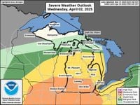
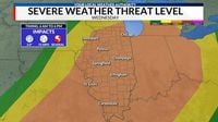
Looking ahead, another strong storm system is set to impact the Midwest on Wednesday, April 2, 2025. This system is expected to bring multiple rounds of storms between 6 a.m. and 6 p.m. on Wednesday, with the most significant chances for severe storms occurring along and east of the Illinois River. The Storm Prediction Center has placed most of Illinois under a Level 3 Risk for severe weather, indicating that all severe hazards, including very large hail, damaging winds, and tornadoes, are possible.
Morning thunderstorms are anticipated to reach western portions of the area between 6 a.m. and 9 a.m. If these storms maintain their strength, they could produce damaging winds and tornadoes, which may limit the potential for severe storms later in the day. However, if the atmosphere recovers, a second round of severe weather could develop along the Illinois River between 11 a.m. and 2 p.m., with storms capable of producing very large hail up to 2 inches in diameter and wind gusts of up to 75 mph.
Residents in affected areas are urged to stay weather-aware and have a plan in place for severe weather. As the active weather pattern continues, it is crucial to monitor local forecasts and stay informed about potential storm developments.