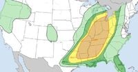
On March 30, 2025, millions of Americans found themselves bracing for severe weather as forecasters warned that over 100 million people across the east-central and mid-southern United States faced a substantial risk of thunderstorms, large hail, and tornadoes. The National Oceanic and Atmospheric Administration’s (NOAA) Storm Prediction Center described the situation as a widespread severe weather episode, particularly affecting areas centered on the Ohio, Mid and Lower Mississippi, Lower Missouri, and Tennessee River Valleys.
With cities like Indianapolis, Indiana; St. Louis, Missouri; Nashville, Tennessee; and Little Rock, Arkansas, under an enhanced risk level—the third-highest out of five—residents were advised to prepare for severe storms capable of producing hail the size of an inch (2.5 cm), wind gusts reaching 58 miles per hour (93 kph), and potentially devastating tornadoes. The Storm Prediction Center also highlighted the possibility of storms producing hail measuring at least two inches (5 cm) in diameter and wind gusts of 75 miles per hour (120 kph).
The timeline for the storms indicated that the first of two waves of thunderstorms was expected to roll in early Sunday morning, particularly affecting the western regions of the at-risk areas. As the day progressed, forecasters anticipated that severe storms would develop along a cold front, moving eastward through the afternoon and evening hours.
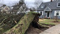
On the same day, reports from NBC affiliate WNDU in South Bend, Indiana, confirmed that the storm system had already begun causing damage. Footage showed significant wind damage, including flattened structures and uprooted trees in the Michiana region. South Bend Police Department spokesperson Ashley O'Chap noted, "The damage is fairly widespread across our city. It was truly an all-hands-on-deck type of afternoon here." Meanwhile, power outages affected over 97,000 electricity customers in Indiana alone, with additional outages reported in Kentucky, Ohio, Michigan, and Wisconsin.
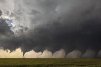
The severe weather threat was exacerbated by a strong low-pressure system moving across the central United States. This system was drawing warm, moist air from the Gulf of Mexico while cold air from the north created a volatile atmosphere ripe for tornado formation. AccuWeather meteorologists indicated that more than a dozen tornadoes could occur throughout the day, particularly targeting cities such as Little Rock, Memphis, and Nashville.
As evening approached, parts of Tennessee, Arkansas, Kentucky, and Missouri were placed under tornado watches and warnings. Destructive wind gusts exceeding 65 miles per hour were reported, with a gust of 85 miles per hour recorded in Baxter Springs, Kansas. Reports of hail up to 2.5 inches in diameter emerged from Oklahoma, and severe thunderstorms continued to pose a threat into the night.
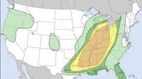
By March 31, 2025, the severe weather threat was expected to shift eastward, impacting areas from Louisiana to New York. The National Weather Service indicated that the storms could produce damaging winds and isolated tornadoes, particularly affecting major highways and urban centers along the eastern seaboard. The highest risk of tornadoes was forecasted to cover southern Alabama into Virginia.
The Storm Prediction Center utilizes a five-level risk category system to assess severe weather threats, ranging from marginal to high risk. An enhanced risk indicates a higher likelihood of severe storms, while a moderate or high risk signifies the potential for widespread, long-lasting, and intense weather events.
As the storm system continued its march across the country, it left a trail of destruction in its wake. In addition to the severe thunderstorms, parts of the Upper Midwest and Great Lakes regions faced winter weather challenges, with reports of significant snowfall and freezing rain. North Trowbridge Park, Michigan, recorded nearly 14 inches of snow within a 24-hour period, while winter alerts remained in effect for millions in the region.
Moreover, the severe weather was not limited to the Midwest and South. In the West, approximately 5 million people faced alerts due to high wind gusts, raising fire concerns from Colorado to Texas. The National Weather Service cautioned residents about the potential dangers of severe weather, emphasizing the importance of preparedness and safety measures.
Understanding the difference between weather watches and warnings is crucial during severe weather events. A watch indicates that conditions are favorable for severe weather to develop, while a warning signifies that severe weather is imminent or already occurring. Residents are advised to seek shelter immediately when a tornado warning is issued.
For those in mobile homes, the safest course of action is to seek sturdier shelter, as mobile homes are particularly vulnerable to tornadoes. The National Weather Service recommends finding a basement or an interior room in a secure building during severe weather. If caught outside, it is best to find a sturdy building for shelter rather than seeking refuge under an overpass, which can create dangerous wind tunnels.
As the storms continued to move east, the potential for additional severe weather remained high. The Storm Prediction Center has already outlined areas in the Ohio Valley for the possibility of severe weather again on April 2, 2025. The ongoing tug-of-war between warm, humid air and cold fronts from the north indicates that the spring season will continue to produce volatile weather patterns.
The bottom line is that millions of Americans are under the threat of severe weather as a powerful cold front moves across the central United States. Damaging winds, large hail, and significant tornadoes are all possible, making it essential for residents to stay informed and prepared.