As severe weather continues to impact regions across the Midwest and South, millions are bracing for dangerous conditions this weekend. Multiple rounds of thunderstorms are anticipated, bringing threats of tornadoes, damaging hail, and destructive straight-line winds, along with extreme rainfall that could lead to life-threatening flooding.
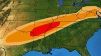
According to the National Oceanic and Atmospheric Administration's Storm Prediction Center (SPC), the most immediate threat on Thursday, April 3, 2025, will be from northeast Texas to western Tennessee, including cities like Memphis and Little Rock. Forecasts predict several tornadoes and very large hail in these areas, with scattered severe storms also possible from northern Texas to the Tennessee Valley and mid-Atlantic regions. The primary threats include wind damage and large hail, with a few tornadoes also likely.
Moving into Friday, April 4, the severe weather risk shifts to central and eastern Texas, extending into the Ohio Valley. Meteorologists expect storms that could produce wind damage, large hail, and a few tornadoes. This pattern of severe weather will peak on Saturday, April 5, especially in the lower Mississippi Valley, while scattered storms may reach as far north as the Ohio Valley. The potential for damaging winds, large hail, and tornadoes remains high, with updated forecasts expected as the situation evolves.
On Sunday, April 6, lingering severe storm threats could affect parts of Georgia, Alabama, and northern Florida, as the storm system continues to travel eastward.
The SPC has issued a rare Level 5 out of 5 "high risk" alert for parts of Arkansas, Missouri, Illinois, Kentucky, Tennessee, and Mississippi, indicating the potential for a significant tornado outbreak. This is only the second time this year that such a high-risk alert has been issued, with the previous alert occurring on March 15, 2025, when 13 tornadoes were confirmed, including six powerful EF-3s that tragically resulted in seven deaths and 12 injuries.
Britta Merwin, a meteorologist with FOX Weather, highlighted that the current outbreak could produce long-track EF-3 or stronger tornadoes, with some tornadoes potentially tracking on the ground for extended periods, causing widespread damage. The threat also extends beyond the immediate high-risk zone, reaching from North Texas to the southern Great Lakes.
In addition to the tornado threat, the SPC warns of hail larger than 2 inches and wind gusts exceeding 70 mph. Flooding is also a significant concern, with the highest flooding threat stretching from Indiana to Arkansas on Wednesday, April 2, and continuing into Thursday, especially in western Kentucky, the Bootheel of Missouri, West Tennessee, and northeastern Arkansas.
As the storms unfold, residents in affected areas are advised to stay informed and take necessary precautions. A couple in Missouri, whose home was destroyed by a tornado, found some of their wedding photos about 100 miles away, providing a glimmer of hope amidst the devastation.
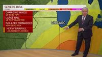
In the Chicago area, the threat of severe weather was palpable on Wednesday, April 2. Following a stormy morning, additional storms were expected to impact northern Illinois and northwest Indiana. The Storm Prediction Center had initially placed much of the Chicago area under an "enhanced" risk for severe storms, but forecasts later adjusted to a lower "slight" risk for areas south and west of Chicago, and a "marginal" risk for areas north.
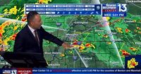
A tornado watch remained in effect for parts of the Chicago area, specifically for LaPorte County in northwest Indiana. A severe thunderstorm warning was also issued for east-central LaPorte County and St. Joseph County in Indiana, where storms were reported moving northeast at 60 miles per hour and producing wind gusts over 70 mph.
The National Weather Service indicated that waves of rain would continue throughout the day, with the most significant threat for severe weather expected in the early afternoon. Damaging winds, large hail, isolated tornadoes, and heavy rainfall were all possible as temperatures hovered in the low-40s before a dramatic shift was anticipated.
By 2 p.m., radar projections showed storm cells beginning to break up, potentially indicating a larger threat for damaging storms. The National Weather Service expressed "high confidence" that parts of northwest Indiana would experience damaging winds of 60 to 75 mph. Embedded tornadoes were also a concern, particularly along and south of US-24.
As temperatures were expected to rise to near 70 degrees in some areas, the storms were predicted to clear out by the evening and overnight hours, with the severe threat diminishing by 7 p.m. CT. However, another chance for storms was anticipated to move in again on Friday evening, continuing into the weekend.
With severe weather affecting millions across the Midwest and South, residents are urged to remain vigilant and prepared. The evolving weather conditions serve as a stark reminder of the power of nature and the importance of staying informed during such critical times.
