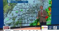
As severe weather looms over Middle Tennessee, residents are bracing for a tumultuous night ahead. A Storm 5 Alert has been issued for the region, with forecasts indicating the potential for damaging winds, large hail, and even tornadoes. The National Weather Service has warned that storms could begin as early as 9 p.m. on March 30, 2025, with the most severe conditions expected between 11 p.m. and 2 a.m.
The weather forecast for tonight predicts a low of 59 degrees with south-southwest winds at 10 to 20 mph. In addition, a Tornado Watch is currently in effect for most of Middle Tennessee and Southern Kentucky until 3 a.m. on March 31, 2025. The Storm Prediction Center has classified the risk of severe weather as an "Enhanced Risk," indicating that all modes of severe weather are possible, including wind gusts exceeding 80 mph and hail as large as 2 inches.
"Storms will form to our west late today then move our way this evening and overnight," stated the National Weather Service in a post on X, formerly known as Twitter. They urged residents to prepare their safe places and to be ready to act if a warning is issued. With the storms expected to hit Clarksville by 8 p.m., the urgency for preparedness is palpable.
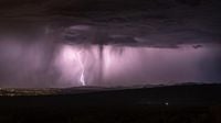
As the storms approach, the threat of tornadoes has heightened. The Storm Prediction Center warned that tornadoes could reach EF-2 strength or stronger, making it essential for residents to remain vigilant. The storms are expected to last through the early morning hours, with winds and rain potentially lingering until 6 a.m. on Monday, March 31, 2025.
In Nashville, the severe weather could lead to rainfall amounts between 1 and 2 inches, and scattered showers may continue throughout the day on Monday. The forecast predicts a high of 65 degrees with a chance of showers and thunderstorms before 10 a.m., followed by a slight chance of rain later in the day. Tuesday is expected to bring mostly sunny skies with a high near 70 degrees.
Residents are reminded to have a reliable way to receive storm alerts while they sleep, as the timing of these storms could pose additional risks. A Tornado Warning has already been issued for Lawrence, Lewis, and Wayne counties until 1:15 a.m. on March 31, 2025, indicating that the threat is already manifesting in some areas.
Looking ahead, the severe weather threat is not expected to dissipate quickly. The National Weather Service has indicated that more severe weather could be on the horizon, particularly on Wednesday evening and again on Thursday. A stationary front across northwestern counties could lead to heavy rainfall from April 2 through April 5, potentially causing flooding in those areas.
"Get your safe places ready, then MOVE IT! MOVE IT! to that place if a warning is issued," the Weather Service urged, emphasizing the need for preparedness as the storm system approaches. Residents are advised to download weather apps and stay informed through local news outlets to ensure they receive timely updates.
As the night unfolds, the community will be watching closely, hoping for the best but preparing for the worst. With a history of severe weather in the region, the stakes are high, and the need for caution cannot be overstated. The coming hours will test the resilience of Middle Tennessee as it faces the elements head-on.
In summary, the severe weather forecast for March 30, 2025, is a stark reminder of nature's unpredictability. As residents prepare for the impending storms, the importance of community awareness and preparedness is more critical than ever. This weather event serves as a call to action for all, urging them to stay informed, stay safe, and heed the warnings issued by meteorological authorities.