DALLAS – A multiday severe weather and flash flood threat continues on Tuesday, May 6, 2025, with millions of people across Texas and Louisiana bracing for storms that could produce baseball-sized hail, strong tornadoes, and potentially life-threatening flooding. The ominous forecast comes as search and rescue crews are actively looking for a 10-year-old girl who was swept away by floodwaters in Brenham, Texas, and first responders are racing to extinguish a fire after a home was struck by lightning.
The severe weather threat persisted overnight and into Tuesday morning, prompting the National Weather Service (NWS) to issue Severe Thunderstorm Warnings and Tornado Warnings in various regions of Texas. A Tornado Watch has been issued for over 10 million people in Texas, including major cities such as Houston, Waco, and Austin, and will remain in effect until 4 p.m. CT.
Forecasters from NOAA’s Storm Prediction Center (SPC) indicate that the highest risk of severe weather on Tuesday will be concentrated across a large swath of Texas and Louisiana. Tens of millions of residents have been placed in a Level 2 risk category on the SPC’s 5-point severe thunderstorm risk scale. A Level 3 out of 5 risk includes nearly 4 million people in cities like Beaumont, College Station, The Woodlands, Bryan, and Temple.
As storms develop, very large hail, strong tornadoes (EF-2 or higher), and damaging wind gusts are all possible. The NWS urges residents to download the free FOX Weather app and enable notifications to stay alert for any watches or warnings issued in their area.
Flooding remains a significant concern as powerful storms move across the southern Plains and along the Gulf Coast, putting millions on alert for potentially life-threatening flash flooding. The highest flash flood threat is expected to begin by midday on Tuesday in portions of East Texas and Louisiana, with storms continuing to impact the area overnight into Wednesday morning.
The strongest storms and heaviest rainfall are anticipated along the Gulf Coast by Wednesday morning, eventually extending into the Florida Panhandle. Flash flooding is likely from the southern Plains to the Southeast on Tuesday. NOAA's Weather Prediction Center has placed portions of East Texas, most of Louisiana, southern Arkansas, and southern Mississippi in a Level 3 out of 4 threat for flash flooding. This includes cities like Shreveport, Alexandria, Baton Rouge, and New Orleans in Louisiana, as well as Jackson in Mississippi.
Residents in these areas should prepare for significant rainfall, with southern Louisiana and southern Mississippi potentially receiving 5 to 8 inches of rain, with some localized higher amounts expected.
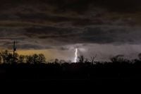
In addition to the severe weather threats, the NWS has specifically warned of tornado activity in the Hill Country area of Texas. Earlier on Tuesday morning, a tornado warning was issued for the Johnson City area and northwest Blanco Counties at 7:17 a.m. Residents in and around Luckenbach, Stonewall, and Hye were advised to seek shelter immediately. Another tornado warning was issued for Marble Falls, Horseshoe Bay, and Meadowlakes until 8:30 a.m.
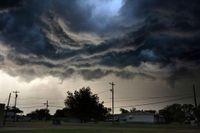
As dark storm clouds loom over Texas, radar indicates a possible tornado in those areas, and quarter-sized hail is also likely with this storm system. A severe thunderstorm watch is currently in effect through 10 a.m. for the Hill Country area, where tennis-ball-sized hail, along with a couple of tornadoes and wind gusts reaching 65 mph, are anticipated in counties such as Bandera, Edwards, Kendall, Kerr, Medina, and Real.
The NWS has stressed that the highest potential for severe weather is today, but isolated storms could linger through Wednesday, May 7, 2025. Residents in Lee County and parts of eastern Williamson, northeastern Travis, northern Bastrop, and northern Fayette counties are urged to stay alert for weather warnings in their areas.
This severe weather event is attributed to a jammed-up weather pattern known as an omega block, which is currently affecting large portions of the country. This pattern, characterized by a jet stream shaped like the Greek letter omega, has been causing heavy rain and flooding across the Great Plains and is expected to linger for several more days before clearing out by the weekend.
As the storm systems move through Texas, residents are reminded of the difference between a tornado watch and a tornado warning. A tornado watch indicates that conditions are favorable for tornadoes to develop, while a tornado warning signifies that a tornado is either occurring or imminent, and immediate shelter is necessary.
With tornado season in Texas typically running from April to June, and May being the peak month for tornado formation, residents are advised to remain vigilant and prepared for potentially severe weather conditions.
The combination of severe thunderstorms and the risk of tornadoes highlights the importance of staying informed and ready to respond to emergencies as they arise. As Texas and Louisiana brace for the ongoing threat of severe weather, the community remains hopeful for the safe return of the missing child and for the safety of all residents in the affected areas.