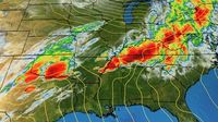
As torrential rains sweep across the southeastern United States, residents are bracing for a weekend of severe weather. On Saturday, May 10, 2025, the National Weather Service issued a flood advisory for Tuscaloosa County, Alabama, effective until 4:15 p.m. The advisory warns of urban and small stream flooding caused by excessive rainfall, predicting minor flooding in low-lying and poorly drained areas.
"Urban and small stream flooding caused by excessive rainfall is expected," the weather service stated, urging caution among drivers. The advisory includes a stark reminder: "Turn around, don't drown when encountering flooded roads. Most flood deaths occur in vehicles." With just 12 inches of rushing water capable of sweeping away most vehicles, the risks are high for those who underestimate the power of floodwaters.
Adding to the mix, Central Florida is also facing a rainy weekend, with the Storm Prediction Center placing most of the area under an isolated severe weather threat. The WESH 2 First Warning Weather team has issued an Impact Weather alert for Saturday, indicating that conditions could disrupt travel and daily activities. The threats include hail and wind, particularly from 4 p.m. to 10 p.m., with a forecast of 60% rain coverage.
As the storms roll in, the Federal Aviation Administration has issued a ground delay at Orlando International Airport due to thunderstorms, which will remain in effect until 7:59 p.m. A previous ground stop had been lifted earlier in the afternoon. Travelers are advised to stay updated as Mother’s Day, Sunday, May 11, is expected to be stormy, with showers and storms anticipated in the afternoon.
Looking ahead, a cold front is expected to move through Central Florida between Monday, May 12, and Tuesday, May 13, bringing even more rain. Forecasts predict up to 70% rain coverage on Monday, with lingering showers possible on Tuesday. Fortunately, the weather is expected to clear up by Wednesday and Thursday, with sunshine and dry air returning.
In light of the severe weather warnings, it’s crucial for residents in affected areas to understand the different types of weather alerts. A flash flood warning indicates that a flash flood is imminent or occurring, urging immediate action to seek higher ground. Conversely, a flood warning is issued when flooding is imminent or occurring, while a flood advisory serves as a cautionary notice that flooding may not be severe but could still pose risks to life and property.
The National Weather Service emphasizes the importance of safety during such weather events. They advise residents in flood-prone areas to seek higher ground, follow evacuation orders, and disconnect utilities and appliances if time permits. Avoiding basements and submerged areas is crucial, as electrical hazards can arise during flooding.
"If you notice sparks or hear buzzing, crackling, snapping, or popping sounds, evacuate without delay," the weather service warns. It’s vital to avoid walking through floodwaters, as even six inches of swiftly moving water can knock a person off their feet. If trapped by moving water, the best course of action is to reach the highest point possible and contact emergency services.
For those navigating the roads during heavy rain, the National Weather Service provides several safety tips. Drivers should maintain safe distances using the two-second rule and allow for an additional two seconds in heavy rain. Reducing speed and driving cautiously is essential, especially during the first half-hour after rain begins, when roads can be particularly slippery due to a mix of grime, oil, and water.
Choosing the right lane is also important; sticking to middle lanes minimizes the risk of hydroplaning, as outer lanes are more prone to water accumulation. Visibility can be severely impacted during rain, so drivers are advised to turn on their headlights and be vigilant of other vehicles.
Moreover, it’s wise to keep a safe distance from large vehicles, which can create spray that reduces visibility. If visibility becomes severely limited, drivers should pull over to a safe location and wait for conditions to improve.
As the weekend unfolds with challenging weather conditions, residents are reminded to stay informed and heed guidance from local authorities. Safety should always be the top priority, especially as storms bring the potential for flooding and hazardous driving conditions.
In summary, whether in Alabama or Florida, the weekend weather poses significant challenges. With flood advisories in effect and severe weather warnings issued, residents must remain vigilant and prepared. By following safety guidelines and staying informed, they can navigate these tumultuous conditions more safely.