North Texas is bracing for an active weekend of weather, with scattered showers expected to persist through Friday afternoon, March 28, 2025. A First Alert Weather Day has been declared, signaling the potential for severe thunderstorms as the weekend approaches. According to the National Weather Service, the region will experience a mixture of rain, thunder, and strong winds, particularly on Saturday and Sunday.
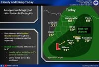
On Friday morning, residents can expect a wet commute, as scattered showers and slick roads are anticipated. The heaviest rainfall is predicted to occur in Collin, Rockwall, and Kaufman counties, where visibility has already dropped to two miles due to the downpour. By evening, the rain is expected to move east of the Dallas-Fort Worth Metroplex, with total accumulations reaching between 0.5 to 1.5 inches in some areas.
Temperatures on Friday will struggle to reach the upper 60s, peaking around 68 degrees. The day will remain cloudy and mild, with winds blowing from the south at 10 to 20 mph. As night falls, patchy drizzle and fog may develop, leading into a cooler Saturday morning.
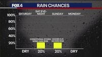
Looking ahead to Saturday, March 29, conditions will shift significantly. The morning will start cloudy with fog and drizzle, but skies are expected to clear by the afternoon. Temperatures will rise into the mid-80s, making for a warm day. However, as the dryline pushes in from West Texas, the possibility of isolated severe storms will increase, particularly in areas northwest of the Dallas-Fort Worth region. The primary threats from these storms will be hail and strong winds.
By Saturday evening, there is a 20% to 30% chance of isolated strong storms, especially in East Texas. The National Weather Service has issued a marginal risk for severe weather, emphasizing the need for residents to stay informed and prepared.
Sunday, March 30, will see a continuation of the warm and humid conditions, with a higher risk for severe storms, particularly in the afternoon and evening. A cold front is expected to sweep across North Texas, colliding with sufficient moisture and instability. This could lead to scattered severe storms throughout the region, with damaging winds and large hail being the main concerns. There is even the potential for an isolated tornado, adding to the urgency of the situation.
The timing for these storms is projected to begin after lunchtime on Sunday, continuing into the evening hours. As the cold front passes, temperatures will drop, with highs only reaching the low 70s on Monday, March 31, marking a significant change from the warmth of the weekend.
Looking beyond the weekend, the weather will stabilize. Early next week is expected to be cool and dry, with afternoon highs only reaching the upper 60s on Monday. Some areas may see temperatures dip into the 40s by Tuesday morning, April 1, before rebounding into the mid to upper 70s with plenty of sunshine.
As the week progresses, there are indications of more rain and potential thunderstorms returning to the region on Wednesday and Thursday, April 2 and 3, with afternoon highs in the upper 70s and low 80s.
In summary, North Texas residents should prepare for a weekend of varied weather conditions, from showers and thunderstorms on Friday to potential severe storms on Saturday and Sunday. Staying informed through local weather updates will be crucial as the situation develops.