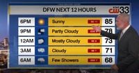
DALLAS (KDAF) — As North Texas braces for a week of unpredictable weather, meteorologists are forecasting a mix of sunshine and potential storms. On April 22, 2025, meteorologist Brian James predicted a warm day with a high temperature of 85 degrees, followed by clouds and a slight chance of rain in the evening.
However, the forecast isn't all sunshine. The Dallas-Fort Worth area is expected to experience two rounds of storms starting Tuesday night, with a low possibility of isolated severe weather. According to the National Weather Service (NWS) in Fort Worth, following a weekend of tornadoes reported in counties west of Dallas, the chances of severe weather this week remain low and isolated.
“High winds and hail will be the main threats from any stronger storms,” the NWS stated. Rain is expected to begin around 8 p.m. on April 22, with a 15% chance of precipitation. A weak batch of storms is forecasted to approach Dallas from the west around midnight, leading to persistent rain through the morning of April 23.
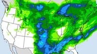
In fact, the National Weather Service has warned of severe storms capable of producing baseball-sized hail, damaging winds, and isolated tornadoes across Texas, particularly in regions including Midland-Odessa, Dallas-Fort Worth, and Lubbock. The threat is expected to last from Tuesday through at least Friday, April 25, 2025, as storms track eastward across the state.
On Tuesday, scattered storms are anticipated across Texas. The NWS in Midland has indicated a medium risk of severe storms Tuesday afternoon and evening, particularly east of a Tatum-to-Panther Junction line. Areas in the Permian Basin and southern High Plains may experience large hail, damaging winds, and isolated tornadoes.
As meteorologist Matthew Cappucci from MyRadar noted, airflow around the Trans-Pecos, Davis, and Glass mountains may enhance tornado potential near I-10 in the Fort Stockton area. Meanwhile, thunderstorms are expected across much of the South Plains region, with some storms potentially reaching severe levels, producing large hail and damaging wind gusts.
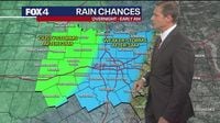
For the Dallas-Fort Worth area, the first round of storms will consist of isolated afternoon thunderstorms primarily south of I-20 and along or east of the I-35 corridor. However, forecasters expect these storms to weaken quickly after sunset. A second round of storms may arrive after midnight, with the best rain chances (around 40%) forecasted for western North and Central Texas.
Wednesday, April 23, is expected to bring a “sneaky tornado risk” across West Texas. As moisture levels increase, supercells may develop along the dryline, where dry desert air meets Gulf moisture. This could lead to threats of destructive hail up to baseball size, 70+ mph winds, and isolated tornadoes near areas like Lamesa, Big Spring, and Snyder. Such setups have previously triggered tornadoes in the region, including incidents near Anson and Hawley in May 2024.
The National Weather Service office in Midland has also indicated a medium risk of severe thunderstorms expected on Thursday afternoon and evening, particularly over the Western Low Rolling Plains and Permian Basin. Any severe storms could bring large hail, damaging winds, and isolated tornadoes.
Looking ahead, the unsettled weather pattern is expected to continue through the end of the week, with scattered showers and storms each day. While a few storms may be strong to marginally severe, the overall risk for widespread severe weather remains low. According to the NWS, storm chances will gradually decrease through the weekend, but are likely to rise again early next week.
For the upcoming days, the forecast is as follows: On Wednesday, expect mostly cloudy skies with a 50% chance of showers and thunderstorms, a low of 64, and a high of 82. Thursday will see mostly cloudy conditions with a 70% chance of showers and thunderstorms, a low of 65, and a high of 80. Friday will maintain similar weather, with a 50% chance of showers and thunderstorms, a low of 64, and a high of 81.
By the weekend, conditions will remain partly to mostly cloudy, with a 30% chance of showers and thunderstorms on Saturday and a 20% chance on Sunday. Highs will remain in the low to mid-80s, while morning lows will be in the 60s each day.
As residents prepare for this tumultuous week of weather, it’s essential to stay informed and ready for any changes. The National Weather Service continues to monitor the situation closely, ensuring that communities across Texas are aware of potential severe weather risks and prepared to take action if necessary.