As millions of Americans prepare for Easter weekend, severe weather looms over the Dallas-Fort Worth area and much of the southern United States. A multi-day severe weather pattern has already wreaked havoc across several states, and meteorologists warn that the worst is yet to come.
On Saturday, April 19, 2025, the National Weather Service issued severe thunderstorm warnings for parts of western North Texas, including the DFW Metroplex. The forecast indicates that strong thunderstorms could bring damaging winds and hail, with the threat extending from Texas all the way to Indiana. This severe weather system has already caused significant damage in other areas, including a tornado that left a trail of destruction in Springdale, Arkansas.
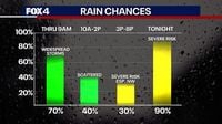
According to FOX 4 meteorologist Kylie Capps, the storms are expected to intensify throughout Saturday, with high coverage of showers and the potential for severe thunderstorms, particularly in the afternoon and evening. "Severe thunderstorm warnings were put in place for counties to the west of the Metroplex in the early morning hours on Saturday, but were allowed to expire," she noted.
The latest forecasts predict that the DFW area could see between 0.1 and 1 inch of rainfall, with isolated areas potentially receiving up to four inches. A flood watch is currently in effect for Cooke, Montague, Jack, and Young counties from 1 a.m. Saturday through 1 p.m. Sunday.
As Saturday progresses, meteorologists anticipate a level 2 out of 5 risk for severe weather, which includes threats of severe hail and damaging wind gusts. The weather is expected to gradually clear up by Sunday afternoon, providing a brief respite for Easter celebrations.
However, the storm threat will ramp up again on Easter Sunday, April 20, 2025. A level 3 out of 5 risk of severe weather will cover much of Missouri, including Springfield and Columbia, and extend into northern Arkansas. This risk zone is expected to affect approximately 20 million people, with storms forecast to develop late in the morning across eastern Kansas and Oklahoma.
As the powerful upper-level storm system moves across the region, meteorologists warn that conditions are aligning for potentially significant severe weather, including the possibility of tornadoes. "This is our biggest risk for severe storms that we've had in this stretch so far," said FOX Weather Meteorologist Jane Minar.
In preparation for the severe weather, residents in affected areas are advised to stay informed and take necessary precautions. The storms may begin to form into a line as they move eastward, leading to widespread thunderstorms and heavy rainfall.
Following the severe weather on Sunday, conditions are expected to improve briefly, with a rain-free day on Monday, April 21, 2025. However, storm chances will return by mid-week, with potential rain forecasted from Tuesday through at least Friday.
As tens of millions of Americans brace for the severe weather, the National Weather Service continues to monitor the situation closely. The agency emphasizes the importance of staying updated with the latest forecasts and warnings.
In summary, this Easter weekend is shaping up to be a tumultuous one for many in the southern U.S., with severe thunderstorms, hail, and the risk of tornadoes looming large. As communities prepare for the storms, the focus remains on safety and preparedness.