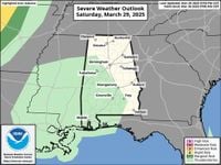
Severe Weather Threat For 100+ Million People
Widespread storms are moving across the eastern half of the U.S. to the East Coast on Monday as March comes to a close. The areas included in this severe threat are some of the same locations impacted by a major severe weather outbreak two weeks ago.
What's Happening Now
The new storm system has fired up a strong line of thunderstorms, and the threat of severe storms and tornadoes will continue through the overnight hours. Early Sunday, March 30, 2025, a wind gust of 85 mph was recorded in Baxter Springs, Kansas, and roof damage and trees down were reported. Joplin, Missouri, measured a wind gust of 79 mph. Hail up to 2.5 inches in diameter fell near Bridge Creek and Amber, Oklahoma. Heavy rain also prompted a flash flood emergency in Mississippi.
Here's where rain and thunderstorms are occurring now:
Through Monday morning, March 31, 2025, widespread severe storms will continue to move eastward overnight from the Gulf Coast to the Great Lakes, including portions of the Mississippi, Ohio, and Tennessee valleys. Very large hail, damaging winds, and strong tornadoes (EF2 or higher damage) are possible for these regions. Severe weather is a concern in the overnight hours in some locations, especially in areas near and east of the Mississippi River, so be sure to have a way to receive alerts to wake you up at night.
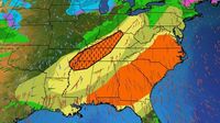
On Monday, March 31, 2025, severe weather continued ahead of a cold front from the northern Gulf Coast into the Southeast, the mid-Atlantic, and Northeast, possibly including Atlanta, Georgia; Charlotte and Raleigh, North Carolina; Jacksonville, Florida; Columbia, South Carolina; and Washington, D.C. Wind damage is the biggest threat from any severe storms that push through the mid-Atlantic and Northeast. In the Southeast, from the Carolinas to Georgia and the Gulf Coast, the storms could produce wind damage, large hail, and a tornado threat.
The best chance for a few tornadoes stretches from southern Alabama into Virginia, as shown in the red area below.
As we begin April, another low-pressure system will bring the threat of severe weather to parts of the Midwest, Ohio Valley, and South midweek. This next round on Wednesday, April 2, 2025, may evolve into "a widespread and potentially substantial outbreak of severe weather," according to NOAA's Storm Prediction Center's outlook issued on Sunday morning.
A Springtime Setup
The setup supporting this multiday severe weather threat is familiar for March and the rest of spring, with a sharp southward plunge of the jet stream swinging out of the West toward the central and eastern states. A strong low-pressure system with embedded strong wind shear will sweep from Kansas to New York over the weekend, helping pull a moisture surge northward from the Gulf. These will lead as potential drivers of severe weather, including supercells.
Part of Monroe County is under a tornado warning until 7:15 p.m. on Sunday, March 30, 2025, according to the National Weather Service. IU Alert advised anyone in the area to seek shelter immediately. The area extends from Clear Creek and nearly to Nashville, Indiana. Monroe County is also under a severe thunderstorm warning until 7:15 p.m. on Sunday, March 30, 2025. Under a warning, which means a tornado has been sighted or indicated by radar, residents should move to the lowest floor of a sturdy building and avoid windows, vehicles, and mobile homes, according to the NWS.