Severe weather continues to wreak havoc across North Texas, particularly in the Dallas-Fort Worth Metroplex, where residents are bracing for another day of intense storms, flash flooding, and potential tornadoes. The National Weather Service (NWS) has issued multiple warnings, indicating that the severe weather threat will persist through Wednesday, April 30, 2025.
As of Wednesday morning, heavy rainfall is expected to result in flash flooding across several counties, including Dallas, Tarrant, Denton, and Collin. The NWS forecasts that areas north of Dallas may receive between 1.5 to 3 inches of rain, with isolated spots potentially seeing up to 5 to 6 inches. This has prompted flash flood warnings that remain in effect until 2:15 p.m. today.
Roughly 13,000 Oncor customers were reported without power across the Dallas-Fort Worth area by noon, with significant outages affecting 3,800 in Dallas County and 7,400 in Tarrant County. The storm system, which began moving into the Metroplex around 10:30 a.m., is part of a larger weather pattern impacting the Southern Plains.
The severe weather threat is not new; it marks the eighth consecutive day of dangerous conditions for the southern and central United States. The NWS has issued a Tornado Watch for parts of North Texas until 5 p.m., with strong tornadoes (EF-2 or higher) possible along the Red River Valley. Meteorologists caution that some tornadoes could be particularly strong and long-lived, posing a significant risk to residents in the area.
In addition to tornado threats, damaging winds and large hail are also concerns. Reports from Tuesday indicated wind gusts reaching 106 mph in Seymour, Texas, and the potential for hail the size of DVDs in Guthrie, Texas. These severe storms caused extensive damage, including power outages affecting hundreds of thousands of homes across multiple states, from Pennsylvania to New York.
Unfortunately, the storms have already resulted in fatalities; at least three people were killed during a recent derecho that swept through the Plains and Midwest. The aftermath has left many communities grappling with the destruction and the ongoing threat of severe weather.
Residents are urged to stay weather-aware and have a plan in place for severe weather. The Fort Worth Fire Department has emphasized the importance of preparedness, especially concerning flash floods, which can occur with little warning. "The water can rise so quickly," said spokesperson Craig Trojacek. "It’s crucial to be aware of your surroundings and to avoid driving through flooded areas, as just a small amount of water can disable your vehicle."
As the day progresses, multiple rounds of storms are anticipated, with the most severe weather expected to hit the heart of the Metroplex around noon. The NWS advises that temperatures will rise into the 70s before dropping into the 60s after the storms pass.
Looking ahead, the severe weather threat is expected to diminish by Thursday, May 1, though the possibility of scattered storms remains in southeastern areas of the Dallas-Fort Worth region. Meteorologists are keeping a close eye on moisture returning to the area by Friday, which could bring more rain and the risk of additional strong storms.
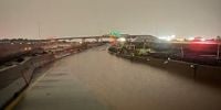
In light of the ongoing severe weather, the NWS has issued safety tips for residents. They advise seeking higher ground if you live in a flood-prone area, avoiding driving through flooded roads, and being cautious around riverbanks. "Minor flooding is forecast for the Trinity River at Dallas," the NWS reported, noting that low water crossings may become inundated.
As the storms continue to develop, local officials are preparing for an increase in emergency calls. Fire-rescue teams in Dallas are equipped with swift water stations and flat water boats to respond to high-water emergencies. They are ready to assist residents in distress, especially in situations involving flooding and lightning strikes.
The community is reminded to stay informed through local news outlets and to have multiple ways to receive alerts. The potential for severe weather is high, and residents are encouraged to take all necessary precautions to ensure their safety.
As North Texas faces another day of severe weather, the combination of heavy rainfall, potential tornadoes, and flash flooding presents a serious challenge for residents and emergency responders alike. With the forecast indicating continued instability, staying vigilant and prepared is crucial for everyone in the affected areas.
As the storm system continues to evolve, updates will be provided as necessary. Residents are advised to heed all warnings and to prioritize safety as the severe weather unfolds.