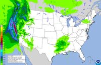
In a dramatic turn of weather events, Northern California is facing severe conditions with a weather system unleashing rain and snow across the region on Monday, March 17, 2025. As a result of the predicted adverse weather, the KCRA 3 weather team has declared an "Impact Day," advising residents of likely travel disruptions and outdoor activity restrictions.
The National Weather Service has issued a winter storm warning for the Sierra, effective until 11 p.m. on Monday. Authorities urge motorists to prepare for chain controls, with certain areas predicted to accumulate as much as two feet of snow. With chain control measures in force, speed limits have been temporarily reduced on major highways—30 mph for Interstate 80 and 25 mph for Highway 50.
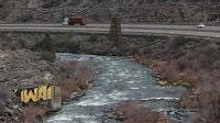
Road conditions on the Sierra routes have been volatile throughout the day. As of 11:04 p.m. on Monday, Interstate 80 remains open to traffic, though chain controls are still required between Baxter and Truckee. Earlier in the day, at 5:38 p.m., a tornado warning covering southwestern Tuolumne and east-central Stanislaus Counties expired, while a new warning for parts of western Mariposa, southwestern Tuolumne, and north-central Merced counties was still in effect until 5:45 p.m.
According to officials from the National Weather Service, a powerful severe thunderstorm capable of producing a tornado was located over Hickman, just eight miles northeast of Turlock, prompting alerts for areas in Stanislaus and Tuolumne counties.
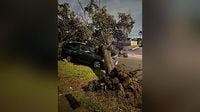
Communities such as Citrus Heights and Folsom faced intense weather, with strong winds and potential hail reported until at least 4:30 p.m. on the same day. Meanwhile, multiple spinouts on Westbound I-80 at Donner Summit led to significant traffic backups and further complications, as noted at 3:59 p.m. Monday.
A severe thunderstorm warning was also issued for parts of Tehama, Butte, and Glenn counties until 4:15 p.m. Traffic disruption continued as of 2:14 p.m., with Caltrans implementing chain controls on Highway 50 from Twin Bridges to Meyers, alongside one-way traffic restrictions near Sierra-at-Tahoe Resort due to a vehicle spinout.
Operators of the California Highway Patrol confirmed that at 1:56 p.m. on Monday, several lane closures on westbound Interstate 80 at Blue Canyon were due to accidents and low visibility. The closures led to an indefinite halt in reopening times as chain controls set in again from Alta to Truckee.
As conditions worsened, chain control requirements were in effect throughout the Sierra area. For instance, as of 7:42 a.m. on March 17, chain controls were mandated on all vehicles, except for those with four-wheel drive and snow tires on major routes. The updates have illustrated the dangers posed by inclement weather.
Meanwhile, authorities continued to monitor the evolving situation and frequently updated road conditions on various interactive platforms. The National Weather Service has also alerted residents to expect further weather warnings, advising caution while traveling.
The Sierra region faced additional challenges later that day as Caltrans reported at 11:19 a.m. that traffic control measures were in effect due to avalanche operations at Echo Summit and Meyers/Chiapa, with no estimated reopening times available. Meanwhile, a special weather statement was issued around 11:07 a.m. for Woodland and Sutter County, predicting gusts of wind reaching up to 30 mph and pea-sized hail until 11:30 a.m.
By Monday evening, conditions were still rapidly changing, and as noted by KCRA 3, the weather system’s impact on travel and daily life in Northern California continues to be a topic of great concern. With multiple weather alerts in place and the forecast suggesting that additional snowfall might be in the offing in the days to follow, local residents remain proactive about their safety efforts.
As for travelers, consistent updates have been made available across various platforms to help navigate the ongoing storm's effects. However, motorists are strongly advised to prepare for more delays, limit travel if possible, and ensure that vehicles comply with the necessary requirements during this unpredictable weather event.
Looking forward, predictions from the National Weather Service indicate more snow could arrive by Wednesday night, likely leading to an additional 1 to 3 inches expected in the Donner Pass region. Constant vigilance remains crucial as Northern California continues to grapple with the ramifications of the recent torrential weather.