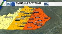
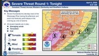
Severe weather swept through central Kentucky on the night of April 2, 2025, after rampaging through western parts of the state, leaving over 12,000 customers without power by midnight, according to poweroutage.us. The National Weather Service (NWS) issued numerous thunderstorm warnings, tornado watches, and tornado warnings for the region, as the storms intensified overnight.
In response to the impending severe weather, Kentucky Governor Andy Beshear declared a state of emergency for the state, warning residents of “severe storms that are intense and long-lived” with risks of tornadoes, hail, flooding, and high winds. “Tornadoes are expected, and I know that’s tough to hear. And we are most concerned about the area of Western Kentucky that has gotten hit far too much,” Beshear stated in a press briefing.
The NWS categorized the storm risk as particularly high for western Kentucky, with central Kentucky under an “enhanced risk” and eastern Kentucky at a “marginal risk.” The storms began to escalate on Wednesday night, signaling a major outbreak of severe weather, including strong, long-track tornadoes, very large hail, and damaging winds that could reach up to 70 miles per hour.
As the storm system moved across the state, it brought heavy rain, hail, and at least one confirmed tornado that struck near Middletown just after 12:30 a.m. on April 3. Reports indicated that more than 8,000 people were left without power in Louisville as the storm continued to wreak havoc.
“This is not a one-and-done event. This is a multi-day event of severe weather,” warned WKYT Chief Meteorologist Chris Bailey. He highlighted that the severe weather was likely to persist, with forecasts predicting near-continuous rain lasting until Sunday evening, April 6. Parts of western Kentucky could see more than 15 inches of rain by the end of the weekend, while Lexington was projected to receive between 6 to 8 inches.
By early Thursday morning, the NWS reported that Fayette County had received nearly an inch of rain in just one hour, and tornado warnings were issued for areas north and south of Lexington, affecting counties including Garrard, Lincoln, Boyle, and southern Madison. Meanwhile, radar indicated wind gusts nearing 70 mph approaching eastern Kentucky.
In the face of the storms, the NWS provided safety tips for residents, advising them to seek shelter during the storm, avoid driving through standing water, and keep essential items like flashlights and cell phones charged and nearby while sleeping. They emphasized the importance of staying low to the ground during a tornado and avoiding windows and doors.
As the storm system moved through the state, reports emerged of significant damage, including four injuries in Gage, where individuals sought shelter in a vehicle under a church carport. The church sustained severe structural damage from debris, and multiple buildings and homes in the community experienced significant damage.
The NWS in Paducah confirmed that they would be busy surveying damage from the storms in the coming days. “We have A LOT of damage surveys to do and have several planned for tomorrow and the days following,” they stated in a social media update.
As the storm progressed, tornado warnings were also issued for the Lexington metro area until 2 a.m. on April 3. Residents were advised to seek shelter, particularly those located near the Kentucky Horse Park and Masterson Station, where strong winds and possible tornadoes were detected on radar.
The fast-moving storm system was traveling at approximately 80 mph, prompting urgent warnings from meteorologists. “Expect a brief period of 55 mph wind gusts, without any storms or necessarily any rain in the area,” the NWS cautioned as the wave moved through Louisville and Bardstown.
As the storm continued, the Catholic Action Center and Lighthouse Ministries opened a shelter for those in need, located at 190 Spruce St., providing refuge for individuals without housing during the storms.
With the threat of severe weather expected to persist, the NWS warned that the biggest concern would shift to flooding after the storms subsided. Upwards of 10 inches of rain was anticipated across much of the state, with western Kentucky potentially receiving as much as 15 inches.
Governor Beshear emphasized the seriousness of the situation, stating, “These can be strong tornadoes, EF-2 and greater. We’re really concerned about people’s safety, especially in the overnight, because when storms or tornadoes hit while people are asleep, that’s sadly when we’ve lost the most people.”
As the storms continue to develop, residents are urged to stay informed through local news channels and heed warnings from the NWS. With the potential for more severe weather on the horizon, safety and preparedness remain paramount.


