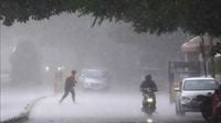
As the weather patterns shift across India, a significant change has been noted over the past 48 hours, bringing relief and challenges to various regions. On the evening of April 11, 2025, strong dust storms swept through Delhi-NCR, while rain accompanied by lightning affected areas from Uttar Pradesh to Bihar. This sudden change has not only cooled the temperatures but also caused disruptions, including fallen trees that impacted traffic and diverted flights.
According to the India Meteorological Department (IMD), pleasant weather is expected over the weekend in Delhi and other parts of the country, following the recent storms. However, forecasts indicate that the weather will stabilize for the next three days, with no significant changes expected. From April 16 onward, heatwaves are anticipated to return to Delhi, raising concerns among residents.
Currently, a Western Disturbance is active over Jammu and Kashmir, while a cyclonic circulation has formed over Madhya Pradesh, extending to northeastern Telangana. This weather system is likely to bring light to moderate rain with thunderstorms across northwest India, with wind speeds reaching 40 to 50 kilometers per hour. Regions like Uttarakhand and Himachal Pradesh may also experience hailstorms and thunderstorms.
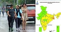
The IMD has issued a yellow alert for several states, including Bihar, Uttar Pradesh, Madhya Pradesh, Maharashtra, Chhattisgarh, Jharkhand, Odisha, West Bengal, Sikkim, Kerala, Tamil Nadu, Karnataka, and the northeastern states, indicating the likelihood of rain and thunderstorms in these areas.
In the eastern states, particularly West Bengal, the IMD has warned of severe thunderstorms and heavy rainfall from April 12 to April 17, 2025. Districts such as Kolkata, Howrah, Hooghly, Digha, Kharagpur, Burdwan, Midnapore, Diamond Harbor, Bankura, and Jhargram are expected to face intense weather conditions, including strong winds that could down trees and power lines. The IMD has also cautioned residents about potential damage to buildings due to storms.
Meanwhile, in northeastern India, heavy rainfall is forecasted over the next few days. The active pre-monsoon weather in Assam, Meghalaya, Tripura, and Mizoram is likely to cause moderate to heavy rainfall throughout the week, with thunderstorms and lightning expected in these regions.
In South India, particularly Kerala, pre-monsoon rains have been ongoing, with heavy rainfall anticipated throughout the week starting from April 13, 2025. This weather pattern is expected to affect most parts of southern India, except for Andhra Pradesh, which may see less impact.
In Uttar Pradesh, the weather has also turned due to rain, leading to a drop in temperatures. On April 13, 2025, the state is likely to experience dust storms and light rain. Meteorologists have noted that the collision of winds from the low-pressure area in eastern Assam and the Western Disturbance could lead to thunderstorms and hail. Earlier, light showers were reported in various regions of UP, providing a brief respite from the heat.
Ranchi, the capital of Jharkhand, is also experiencing fluctuating weather. The IMD has forecasted thunderstorms and rain across most parts of the state, excluding the northwestern areas such as Palamu, Garhwa, Latehar, Chatra, Koderma, and Lohardaga. A yellow alert has been issued, warning residents of potential lightning and strong winds.
As the weather continues to evolve, the IMD has urged the public to remain cautious, especially during storms. Residents are advised to avoid seeking shelter under trees and to stay away from electrical poles during severe weather conditions.
In summary, while the recent storms have brought much-needed relief from the heat in many areas, they have also created challenges, including disruptions to daily life and potential damage to property. The IMD's alerts and forecasts indicate that the weather will remain dynamic, with further changes expected as the country transitions into the pre-monsoon season.