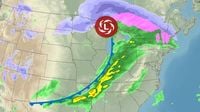
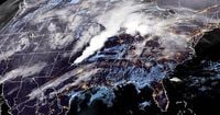
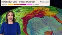
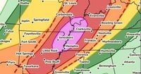
As a powerful spring storm bears down on the central United States, millions brace for a severe weather outbreak that could bring catastrophic tornadoes and unprecedented flooding. On April 2, 2025, the National Weather Service (NWS) has issued a rare Level 5 out of 5 high risk warning across six states, including Arkansas, Missouri, Illinois, Kentucky, Tennessee, and Mississippi, affecting nearly 72 million people.
The storm system is expected to unleash multiple long-track EF-3 tornadoes, with wind gusts surpassing 75 mph and hail larger than 2 inches in diameter. Cities such as Little Rock, Memphis, Louisville, Indianapolis, and Cincinnati are under severe threat, with officials urging residents to remain vigilant and prepared.
Kentucky Governor Andy Beshear declared a state of emergency on Wednesday morning, emphasizing the seriousness of the situation. “We’re under some of the most serious weather threats I’ve seen,” he stated. He noted that the area of Western Kentucky has been hit hard in the past and remains at significant risk.
The NWS warned that extensive and rare flash flooding is likely if the forecast rainfall totals are realized, with some areas potentially receiving up to 15 inches of rain by Sunday, April 6. The forecast indicates that the heavy rainfall could lead to flooding in regions that have rarely experienced such conditions before, with flash floodwater levels expected to reach alarming heights.
“The forecast heavy rainfall in this event has a return interval of anywhere from 25 to 100 years,” the NWS office in Little Rock cautioned. This means that the intensity and duration of the rainfall could be unprecedented, leading to significant disruptions in daily life.
As severe thunderstorms began to develop early Wednesday, tornado watches were already in effect in parts of Missouri, Oklahoma, and Arkansas, set to expire later in the evening. Radar confirmed tornadoes were reported in Missouri and Oklahoma, causing damage and prompting emergency responses.
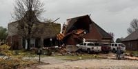
In Owasso, Oklahoma, a tornado left an 11-mile path of destruction, uprooting trees and damaging homes. Similarly, in Nevada, Missouri, a suspected tornado caused extensive damage, with reports of roofs torn off buildings and debris scattered across local streets.
The threat of long-track tornadoes is expected to peak during the afternoon and into the evening, with the Storm Prediction Center warning that supercell thunderstorms capable of producing tornadoes will develop as the day progresses. The NWS has advised individuals to have a severe weather action plan in place, ensuring they can swiftly respond to any tornado warnings.
Beyond the tornado threat, the storm system has also raised concerns about generational flooding. The NWS has indicated that the storms will initiate multiple days of nearly nonstop rain, with forecasts predicting widespread rainfall of 6 to 12 inches across northeastern Texas to southwestern Ohio.
Forecasters predict that the heavy rain will continue into the weekend, with additional rounds of storms expected to bring further flooding risks. “This setup is shaping up to be a more extreme flooding scenario considering the multiday prospects,” the Weather Prediction Center noted.
In addition to the tornado and flooding threats, winter storm warnings have been issued for parts of North Dakota, South Dakota, and Minnesota, where heavy, wet snow is expected. This combination of severe weather across multiple states underscores the complexity and dangers posed by the current storm system.
The severe weather threat is not limited to just one day. The NWS has indicated that the severe threat will continue for several days, with 42 million people at risk on Thursday, April 3, and further threats expected on Friday and Saturday. The weather service has urged communities to prepare for severe disruptions to daily life due to the anticipated extreme rainfall and flood risk.
As the storm system makes its way across the region, residents are advised to stay informed through local news and the NWS for updates on weather warnings and safety measures. With the potential for strong tornadoes and historic flooding, preparedness is crucial.
In summary, as the central United States faces this significant weather event, officials are emphasizing the importance of being proactive and ready to respond to the severe conditions that lie ahead. The combination of tornadoes, flooding, and winter weather creates a complex and dangerous situation that will require vigilance and preparedness from all residents in the affected areas.
