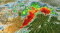
Millions across the Midwest and South are bracing for a severe weather outbreak as a powerful storm system unleashes a barrage of tornadoes, damaging winds, and heavy rainfall. The National Weather Service (NWS) has issued warnings for multiple states, forecasting life-threatening conditions that could extend into the weekend.
On the night of April 2, 2025, a tornado outbreak is expected to sweep through parts of the Midwest and mid-South, with the potential for widespread destruction. According to the NWS, significant tornado activity has already been reported, particularly in Tennessee and Arkansas, where residents have been urged to take shelter.
The greater Memphis area is currently under a tornado watch, with alerts in effect until midnight. Fast-moving storms are expected to bring not only tornadoes but also very large hail and damaging winds. Tornado warnings have already been issued for several locations, including Jackson, Milan, Covington, Nutbush, and Poplar Grove.
As the storm system progresses, the threat of flash flooding looms large. The NWS has indicated that some areas could see rainfall totals of 10 to 15 inches through the weekend, contributing to what officials are calling a "multi-day catastrophic and potentially historic heavy rainfall event." This excessive rainfall is likely to lead to significant flooding, especially in low-lying areas.
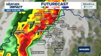
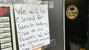
In Indiana, severe thunderstorms capable of producing tornadoes have already begun to impact the Indianapolis metro area. Reports indicate that between 1 to 3 inches of rain is expected to fall, with the potential for double-digit rainfall in southern Indiana. As of late Wednesday night, nearly 70,000 customers were without power due to the severe weather.
At 10:51 p.m. EDT on April 2, 2025, severe thunderstorms capable of producing tornadoes were tracked moving northeast at high speeds, prompting further warnings from the NWS. The agency has confirmed that a tornado was on the ground in Carmel, Indiana, as sirens blared throughout the area.
"There are multiple reports of trees down on the west side of Indianapolis," the Indianapolis Metropolitan Police Department (IMPD) posted on social media, urging residents to take precautions. The NWS has also advised that wind gusts could reach up to 80 mph, creating dangerous conditions for anyone caught outside.
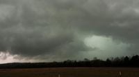
Meanwhile, a large supercell tornado was reported west of Memphis, leading to sirens sounding in the city as residents were warned of the impending danger. Social media posts showed extensive damage in nearby Lake City, Arkansas, where a tornado reportedly caused significant destruction.
As the storm system continues to develop, the NWS has warned that the threat of severe weather will persist into the weekend. Flood watches are in effect across multiple states, with the potential for flash flooding becoming increasingly likely as heavy rains accumulate.
In addition to the tornadoes and flooding, the storm is also expected to bring large hail, with some areas experiencing hailstones the size of baseballs. The NWS has emphasized the importance of being prepared for rapidly changing weather conditions, advising residents to stay informed through local weather updates.
As of now, the NWS is closely monitoring the situation, providing real-time updates and warnings as conditions evolve. Maps and radar images are being updated frequently to help track the storm's path and potential impacts.
With the threat of severe weather looming, officials are urging residents to review their emergency plans and be ready to act quickly if a tornado warning is issued. The NWS recommends moving to an interior room on the lowest floor of a sturdy building and avoiding windows if a tornado warning is issued for your area.
As the storm system moves through the Midwest and South, millions remain on high alert. The combination of tornadoes, damaging winds, and heavy rainfall poses a serious risk to life and property, and residents are advised to stay vigilant and prepared for the worst.
In summary, the severe weather outbreak affecting the Midwest and South is expected to bring a variety of dangerous conditions, including tornadoes, flash flooding, and damaging winds. The NWS continues to provide updates and warnings as the situation unfolds, and residents are advised to stay informed and take necessary precautions to protect themselves and their families.


