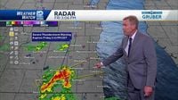
MILWAUKEE - Severe weather swept through southeastern Wisconsin on Friday, April 18, 2025, as the National Weather Service (NWS) issued multiple warnings for thunderstorms and flash floods. The warnings, which included a severe thunderstorm warning for Milwaukee, Racine, Walworth, and Waukesha counties, were in effect until 3:45 p.m. The NWS cautioned residents about the potential for quarter-sized hail and damage to vehicles during the storms.
Earlier in the day, a flash flood warning had also been issued for parts of the area, signaling the severity of the weather conditions. As the day progressed, the threat of severe storms continued, with two distinct rounds of storms expected to impact the region.
According to the forecast, severe thunderstorms were anticipated to bring damaging winds and hail, particularly as a cold front moved through. "We’re watching closely at the moment. It is super quiet here in southeastern Wisconsin, but conditions can change rapidly," said a local meteorologist, emphasizing the need for residents to remain vigilant.
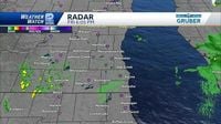
The NWS highlighted that the severe threat was expected to move out by 9 p.m., but a chance for lingering showers remained until about 10 p.m. Overnight, temperatures were predicted to drop, with a low of around 43 degrees.
As the storms approached, the atmosphere was charged with humidity, leading to concerns about the potential for tornadoes, especially near the Illinois border. "There’s still a low tornado risk if we can get some of these storms to pop," the meteorologist noted. "We’ve got a little pocket of clearing, and that’s going to move in now. It’s tough to tell how this will play out before the cold front pushes in. We’re just waiting to see if this area of something will go. If it can get through that cap, it will grow very quickly," he added.
The storms were not just a local concern; they were part of a broader weather pattern affecting the Midwest. As the storms rolled through, the NWS warned of the potential for quarter-size hail and vehicle damage in Rock, Walworth, and Jefferson counties. Residents were urged to monitor local weather updates and prepare for possible disruptions.
In addition to the severe weather warnings, the FOX6 Weather Team provided a variety of resources to help residents navigate the stormy conditions. Their FOX6 Storm Center app offers real-time updates, while the FOX Weather app allows users to access detailed weather maps and radar. Schools and businesses were also advised to stay alert for potential closures due to the inclement weather.
As the weekend approached, the forecast indicated a cooler trend. On Saturday, April 19, a mix of clouds and sun was expected, with highs reaching near 50 degrees near Lake Michigan and mid-50s inland. However, Easter Sunday, April 20, was anticipated to bring rain in the afternoon after a drier morning.
Despite the storms, many residents were hopeful for a pleasant Easter weekend. "Saturday is the pick day, but we’ll have to deal with some rain on Sunday afternoon," said the meteorologist. "It won’t be a total washout, but it will be breezy and cool, with highs in the low and middle 50s."
As the severe weather warnings expired, the community reflected on the importance of being prepared for sudden changes in weather. The NWS and local meteorologists reiterated the need for residents to remain weather-aware, especially during the spring season when storms are more common.
In summary, the severe weather on April 18, 2025, served as a reminder of the unpredictable nature of spring storms in Wisconsin. With the potential for damaging hail and strong winds, residents were encouraged to stay informed and prepared as they navigated the changing weather conditions.