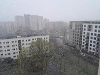
On April 5, 2025, Poland faced a severe weather breakdown that brought a mix of snow, strong winds, and dangerous conditions across the country. The Institute of Meteorology and Water Management (IMGW) issued alerts for almost all of Poland, warning citizens of the impending chaos brought on by a cold front moving from the north. This sudden shift in weather caught many residents off guard, leading to significant disruptions and emergencies.
The storm in Olsztyn, which lasted approximately 20 minutes, featured intense snowfall accompanied by thunder and powerful winds. Residents took to social media to document the unusual sight, sharing videos that showcased the extreme conditions. The storm stretched from Klewki, on the route to Szczytno, through Olsztyn, and reached as far as Rapaty, on the route to Gietrzwałd. Fortunately, as of that day, firefighters reported no significant damage related to the weather, and road services confirmed that all routes remained passable.
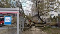
However, the situation was far more dire in Mazowsze, where two people were injured when a tree fell on a bus stop in Warsaw's Żoliborz district. The strong winds, which reached gusts of up to 80 km/h, caused considerable damage to power grids in areas like Ostrołęka and Kosów Lacki near Sokołów Podlaski. By 6:00 PM, firefighters had received around 900 reports related to the severe weather, with the majority of interventions occurring in Mazovia.
As the cold front swept through, temperatures across Poland dropped significantly, reaching a maximum of 4 to 8 degrees Celsius, a notable decrease from the previous day. Meteorologists warned that the chill would be amplified by the strong winds, creating a wind chill effect that made conditions feel even colder. Arleta Unton-Pyziołek, a meteorologist from tvnmeteo.pl, cautioned that wind gusts could reach between 50 and 80 km/h, particularly strong in the northern and eastern regions.
The weather breakdown was attributed to the arrival of arctic air masses. The IMGW warned of potential intermittent rain, sleet, snow, and even hail in some areas. Up to 5 cm of snow was expected in eastern Poland, and in mountainous regions, gusts could even reach 90 km/h, leading to blizzards and snowdrifts. Visibility was expected to be severely reduced, with thunderstorms and snowfall predicted in central, eastern, and southern Poland.
In the evening, reports indicated that the strong winds were causing water from the Vistula Lagoon to flow back into the Elbląg River, resulting in a phenomenon known as backflow. This prompted local authorities to declare a flood alert in the area. Joanna Urbaniak, a spokesperson for the city president, assured the public that services were actively monitoring the situation, although no immediate intervention was necessary.
The severe weather warnings included alerts of the first degree for strong winds across various voivodeships, indicating that average wind speeds could reach up to 35 km/h, with gusts potentially hitting 80 km/h. In some regions, second-degree warnings were issued, particularly for parts of Kuyavian-Pomeranian, Łódź, Mazowieckie, and Warmian-Masurian voivodeships. The Government Security Center also issued alerts predicting even stronger winds from the north, with gusts reaching up to 95 km/h.
In light of these conditions, the IMGW advised residents to exercise caution. Their recommendations included avoiding long journeys, closely monitoring weather forecasts, securing property, and adjusting driving speeds according to road conditions. The alerts highlighted the real threat posed by the weather, with the potential for significant damage to property and risks to health and safety.
The situation in Poland during this weather breakdown serves as a reminder of the unpredictable nature of spring weather. As the country transitions from winter to spring, the clash of warm and cold air can lead to severe weather events. Residents are urged to remain vigilant and prepared for sudden changes in conditions, as the forecasts suggest that the cold snap may persist for several more days.
As the storms continue to develop, many are left wondering whether this is merely a late-season anomaly or a sign of more extreme weather patterns to come. The IMGW’s alerts and the experiences of those in affected regions underscore the importance of preparedness in the face of nature's unpredictability.
![Gwałtowne załamanie pogody. Przez Polskę przechodzą zamiecie [NAGRANIA]](https://thumbor.evrimagaci.org/SRHg98j6mA6atBZC9YmMgAQLZKU=/200x0/tpg%2Fsources%2F6c55d6e1-eeb4-407c-858c-f23fe4185fed.jpeg)