Drivers returning from the long weekend are being warned to take care as New South Wales has been battered by heavy rain and flooding. The NSW State Emergency Service (SES) has responded to 456 incidents over the weekend, with most of the calls concentrated north of Newcastle, extending up to Port Macquarie. In Sydney alone, SES volunteers tackled 67 jobs, while a staggering 309 incidents fell into the northern zone. By mid-afternoon on April 27, 2025, the SES had also been called to six flood rescues.
As the rain continued to pour, Newcastle recorded winds of up to 90 km/h around 1:30 PM, intensifying the already hazardous conditions. The Bureau of Meteorology (BOM) reported heavy local falls in Ulladulla, where about 50 mm of rain fell in just over an hour during lunchtime.
Four vehicles and their passengers were stranded in floodwaters on Sunday, and a young family along with an elderly man found themselves isolated in their homes due to rising floodwaters on Emu Creek Road at Crawford River. This area has seen the most rain in NSW, with approximately 100 mm falling between 9 AM and 4 PM.
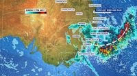
Rainfall was heaviest across the Hunter and mid-north coast regions, with widespread totals ranging from 40 mm to 70 mm, and some areas even pushing into the 80s and 90s. Minor flooding is also predicted along the Cooks River at Tempe Bridge on April 27 and 28 due to the Highest Astronomical Tide, expected to hit between 7:30 PM and 8 PM tonight.
BOM senior meteorologist Miriam Bradbury explained, "This wet weather started at the Anzac Day long weekend. Through Anzac Day, we saw a low-pressure trough moving through western NSW, combined with a low-pressure system in the upper atmosphere that can really enhance the rain and thunderstorms happening at the surface." She warned that heavy falls could lead to flash flooding, creating dangerous driving conditions just as many people were returning home from their long weekend trips.
Bradbury also noted, "Strong winds have been wrapping around the low-pressure system, with 98 km/h recorded at Nobbys Head and 83 km/h at Forbes." The forecast for the upcoming week indicates a mostly dreary spell of weather, with showers expected and temperatures peaking at 24 degrees on Tuesday, April 29.
As the rain continued to pelt down on Hunter roofs, the BOM issued warnings for potential flooding in parts of South Cardiff, Dungog, and Paterson. Low-lying streets adjacent to Winding Creek, South Cardiff, and Fosterson Road were at risk, along with areas near riverbanks and the causeway at Horns Crossing Road in Paterson.
Overnight rain totals from Saturday, April 26, to Sunday, April 27, reached between 50 to 100 millimeters along the Hunter coast. By 10 AM on Sunday, a severe weather warning was in effect for the Hunter region, including Newcastle, Cessnock, and Maitland, indicating the potential for flash flooding, damaging wind gusts, and thunderstorms.
According to the BOM, a six-hourly rainfall total between 50 and 100 millimeters was likely, with isolated falls of up to 140 millimeters possible. Rainfall totals from 9 AM to 3 PM on Sunday ranged from 50 to 100 millimeters in several Hunter suburbs such as Merewether, Dora Creek, Eleebana, and Cooranbong.
Just before 2 PM on Sunday, the BOM indicated that minor flooding was possible at Bulahdelah, as heavy rainfall had caused river level rises along the Myall River. During the 24 hours leading up to 9 AM on Sunday, SES volunteers received 200 calls for help and responded to 85 incidents across the state.
Marine gale warnings were also issued for the Hunter coast, with strong winds forecast for Monday, April 28. The BOM noted that a high chance of rain would likely persist into Thursday, May 1, before dropping to a medium chance of rain on Friday, May 2, and Saturday, May 3. In Scone, a 40 percent chance of zero to one millimeter of rain is predicted for Monday and Tuesday.
As the low-pressure system continues its path, residents are urged to stay informed and heed warnings. The SES has advised against driving, riding, or walking through floodwaters, and to keep clear of creeks and storm drains. If trapped by flash flooding, residents should seek refuge and call for help.
As night fell on April 27, conditions were expected to ease slightly, with the BOM predicting that the low-pressure system would weaken and pull away from the coast, significantly diminishing rain totals. However, the threat of flash flooding remains a serious concern as New South Wales grapples with the aftermath of this intense weather system.