As the long weekend draws to a close, residents in New South Wales (NSW) are facing severe weather conditions, with heavy rainfall leading to flash flooding and dangerous driving conditions. Drivers returning from holiday trips have been urged to exercise caution as the state continues to be battered by rain.
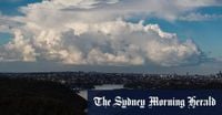
The Bureau of Meteorology has reported that an upper-level low pressure system is moving eastward towards the coast, bringing with it more heavy rain and thunderstorms. Senior meteorologist Miriam Bradbury warned that these conditions could significantly impact travel plans, stating, "If you're travelling for the long weekend or perhaps travelling home for the long weekend, be aware that this heavy rain and the flash flooding may impact your journey."
On April 27, 2025, the weather bureau issued warnings for heavy rainfall and possible flash flooding across large parts of NSW. The mid-north coast, the Hunter region, the central coast, and Sydney's metropolitan area were all expected to experience significant rainfall. The northeast coast of NSW is forecasted to receive widespread rainfall of up to 40mm, with localized thunderstorms potentially bringing totals up to 140mm.
In the six hours leading up to 2:10 AM on April 27, around 117mm of rain was recorded at Collombatti, located on the north coast of NSW. Additionally, peak gusts of wind reaching 90 km/h are expected along the Hunter coast and southern mid-north coast.
The NSW State Emergency Service (SES) has been working tirelessly this weekend, responding to a staggering 456 incidents, many of which have been concentrated north of Newcastle, extending up to Port Macquarie. In Sydney alone, SES volunteers responded to 67 calls for assistance, while 309 incidents were reported in the northern zone.
Most of the calls have related to leaking roofs and fallen trees, but the SES was also called to six flood rescues by mid-afternoon on April 27. "We are seeing heavy rain and winds of up to 90 km/h recorded in Newcastle around 1:30 PM," an SES spokeswoman reported. The impacts of heavy rains have been most acute between Port Stephens and Bulahdelah, where flash flooding is occurring across multiple local roads.
In Ulladulla, heavy local rainfall of about 50mm was recorded in just over an hour during lunchtime on April 27. Additionally, four vehicles and their passengers were stranded in floodwaters, while a young family and an elderly man found themselves isolated in their homes by rising floodwaters on Emu Creek Road at Crawford River, which experienced about 100mm of rain between 9 AM and 4 PM on the same day.
The Bureau of Meteorology predicts that minor flooding along the Cooks River at Tempe Bridge is likely to occur today and tomorrow, coinciding with the Highest Astronomical Tide expected to hit tonight between 7:30 PM and 8 PM. "This wet weather started during the Anzac Day long weekend," Bradbury explained. "Through Anzac Day, we saw a low-pressure trough moving through western NSW, combined with a low-pressure system in the upper atmosphere that can really enhance the rain and thunderstorms happening at the surface."
Bradbury further noted that there is a risk of heavy falls leading to flash flooding, which poses dangerous driving conditions, especially as many people are returning home from long weekend trips. She added that strong winds have been wrapping around the low-pressure system, with 98 km/h recorded at Nobbys Head and 83 km/h at Forbes.
Despite the ongoing adverse weather, there is some good news on the horizon. "Gradually through this evening, overnight and tomorrow, we expect much patchier showers and lower rainfall," Bradbury stated, though she cautioned that the city is set for a mostly dreary week of showers, with temperatures peaking at 24 degrees Celsius on Tuesday.
In light of these conditions, the SES has warned long weekend travelers to stay alert, avoid driving or walking through floodwater, and keep clear of storm drains and creeks. As of April 27, the SES has recorded 64 incidents since 7 PM the previous night, with 14 occurring in Sydney alone.
As the situation develops, residents across NSW have been advised to prepare for potential isolation due to flooding. Warnings have been issued for residents on Darkwood Road and Upper Darkwood Road in Thora, where the Bellinger River may experience an extended peak around the minor flood level. Residents have been urged to consider the effects of isolation on family, work, and educational commitments, as they may be trapped without power, water, and other essential services.
In addition to NSW, parts of Queensland have also been affected by the wild weather, with flood warnings issued as rivers and creeks become inundated with rain. The Sunshine Coast experienced severe conditions, including lightning strikes that resulted in two women being rushed to the hospital.
As for other Australian cities, Melbourne residents are expected to experience calmer weather with a high of 18 degrees Celsius and a slight chance of showers, while Adelaide is forecasted to see possible showers with a maximum of 21 degrees Celsius. Hobart may reach a high of 18 degrees Celsius with potential late showers, and Perth is predicted to have a warmer day with a top of 23 degrees Celsius. Meanwhile, Darwin is expected to be much warmer at 33 degrees Celsius with a slight chance of rain.
The coming days will be crucial for residents as they navigate the aftermath of this severe weather event. With ongoing warnings and the potential for further rainfall, communities are urged to remain vigilant and stay informed about the evolving situation.