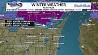
As icy conditions grip Northern Michigan, residents are bracing for a significant winter storm that has prompted the National Weather Service (NWS) to issue Ice Storm Warnings across several counties. The warnings, effective until 8 p.m. on Saturday, March 29, 2025, cover six counties, including Alpena, Montmorency, and Otsego, where additional ice accumulations are expected to reach between two-tenths and three-tenths of an inch. Meanwhile, Cheboygan, Emmet, and Presque Isle counties are forecasted to experience significant icing along with additional snow accumulations up to one inch and ice accumulations between two-tenths and four-tenths of an inch.
The NWS has issued stern warnings regarding road conditions, noting that roads—especially bridges and overpasses—are likely to become slick and hazardous. There is a high potential for power outages and tree damage due to the ice accumulation on power lines and tree limbs. The weather service cautions that travel could become nearly impossible in some areas.
In addition to the ice storm warnings in Northern Michigan, a portion of Eastern Upper Michigan, including Chippewa and Mackinac counties, is under an Ice Storm Warning until 11 a.m. on Saturday. The NWS indicates that significant icing is expected there, with additional snow and sleet accumulations up to one inch and ice accumulations up to one-tenth of an inch.
As of 7:30 a.m. on Saturday, March 29, reports of power outages are already coming in from across Northern Michigan. Presque Isle Electric & Gas has reported approximately 4,000 customers without power, while Great Lakes Energy has reported 9,300 active outages. Consumers Energy also confirmed around 4,000 customers are dealing with power outages.
While Northern Michigan grapples with icy conditions, Southern Lower Michigan is preparing for a different weather scenario. Severe thunderstorms are expected to sweep through the southern part of the state on Sunday, March 30, 2025, from the afternoon into the evening. The National Weather Service warns of risks including large hail, damaging winds, and isolated tornadoes, particularly in southwest Michigan during the evening hours.
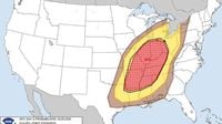
The forecast for Sunday indicates that half of Michigan's Lower Peninsula could experience severe weather, with an enhanced risk of severe thunderstorms, including hail and tornadoes, especially just south of the Michigan-Indiana state line. Rain is expected to move into Southern Lower Michigan by Saturday night, with thunderstorms possible from late Sunday morning into the afternoon and evening, according to the NWS.
The Storm Prediction Center has outlined a substantial severe weather episode across the region, emphasizing the potential for very large hail, damaging winds, and strong tornadoes. The warm weather on Saturday and Sunday—high temperatures expected to be in the upper 60s to low 70s—will be followed by a cold front that triggers the storms.
“Risk will spread eastward with time into the evening/overnight,” the Storm Prediction Center stated in its Friday morning forecast. “Some diminishing of the risk should occur late into the upper Ohio Valley, but vigorous storms and all-hazards risk will likely continue through the end of the period across the Tennessee Valley/Gulf Coast states.”
In the meantime, the NWS office in Grand Rapids has noted that West Michigan could also experience stormy weather, particularly south of M-46. Showers and thunderstorms are expected after 2 p.m. on Sunday, March 30, with high temperatures around 66 degrees. The temperature is predicted to drop to 34 degrees overnight, with a high of 29 on Monday, March 31.
Meanwhile, the Lansing area can expect showers with possible thunderstorms to arrive around 11 a.m. on Sunday. The high temperature is projected to be around 67 degrees, dropping to 37 as the cold front passes through the state. Monday's high is expected to be about 43 degrees.
For the Tri-Cities area, including Midland, Bay City, and Saginaw, rain with possible storms is forecasted after 11 a.m. on Sunday. Highs on Sunday should be in the 60s, followed by lows Sunday night in the upper 30s and highs on Monday in the low 40s.
In Northern Michigan, a band stretching from around Ludington northeast to Alpena is in an area of marginal risk for severe thunderstorms. The Gaylord NWS office has indicated that the ice and freezing rain on Saturday will transition to all rain with some thunder possible by 11 a.m. on Sunday. Alpena is expected to see rain with possible thunderstorms after 5 p.m. on Sunday, while Mackinaw City is forecasted to receive a wintry mix of precipitation.
Temperatures across the region will remain cold, with highs on Sunday in the 40s near Gaylord and in the 30s near Mackinaw City. The highs are expected to drop to the 20s on Monday, with more freezing rain or snow likely.
As the weekend unfolds, much of the Upper Peninsula is under an ice storm warning, with the Keewenaw Peninsula facing a winter storm warning and the western counties of the U.P. under a winter weather advisory. Snow and freezing rain are expected to continue into Monday, with highs in the low 30s and lows in the 20s.
As the weather systems move through Michigan, residents are advised to stay informed and take necessary precautions to ensure their safety during these potentially hazardous conditions.