BATON ROUGE, La. — Severe weather has prompted widespread school closures and safety advisories across the Capital Region today, March 31, 2025, as residents brace for a line of strong storms expected to sweep through the area.
The Zachary Community School District announced the cancellation of classes due to dangerous weather and road conditions. In a statement on Facebook, the district said, "Due to dangerous weather and road conditions, all schools will be closed today. If your student was already on a bus they can be picked up at their school when the weather passes. Thank you and please stay safe. Messages were sent out and are not going through or are delayed. We apologize if you have not received a message." This decision reflects a growing concern for student safety as severe weather looms.
Similarly, East Baton Rouge Parish (EBR) schools have excused tardies and absences until 9:30 AM, urging families to prioritize safety during their morning commute. "We encourage everyone to use their best judgment when traveling to school and to put safety first," the district stated. They expressed appreciation for the community's understanding as they navigate these challenging conditions.
Livingston Schools have also taken precautions, reminding parents that any student arriving late due to the severe weather will be excused. The district emphasized, "The safety of your family and our students remains our highest priority. Thank you for your cooperation and stay safe."
In St. Helena Parish, schools are on high alert due to a tornado warning in effect until 7:15 AM. The district reported that all buses would remain stationary until it is safe to drive on the roads. Parents were informed that if they chose to keep their children home today, it would not count against their attendance. The situation remains fluid, and officials are committed to keeping families updated as conditions evolve.
On the other hand, Tangipahoa Parish Schools remain open but are also excusing late arrivals, advising parents to use their best judgment regarding travel. "The safety of your family and our students remains our highest priority," they reiterated.
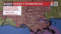
As the storm system approaches, the National Weather Service (NWS) has issued warnings for strong to severe storms expected from early Monday morning through approximately 1 PM. State Climatologist Jay Grymes warned on Sunday, "The morning commute could be a mess for the Red Stick. The main threats will be wind damage, but a rogue tornado can’t be ruled out.”
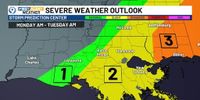
According to NWS meteorologists, the primary hazards of the storm include damaging wind gusts exceeding 60 mph and hail up to 1 inch in diameter. The Baton Rouge and New Orleans metro areas are currently under a Slight Risk (Level 2 of 5) for severe weather on Monday. Although flooding is not anticipated to be a significant concern, forecasters are monitoring conditions due to already saturated ground from the weekend's rainfall.
Forecasts indicate that storms are expected to hit Livingston Parish and areas to the west between 3 AM and 8 AM, while areas east of Livingston Parish can expect storms from 6 AM to 1 PM. The immediate Baton Rouge area is classified as having a slight risk for severe storms, with risks decreasing westward and increasing eastward.
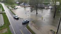
As the storms roll in, residents are urged to stay vigilant. The NWS noted, "Heavy rain will accompany these storms, but they will be moving at a good pace. Given we are already primed with saturated grounds, it wouldn’t take much to push some of the hardest hit areas into flooding.”
Looking ahead, Tuesday, April 1, is expected to be mostly quiet with dry and warm weather returning. Grymes indicated that the Storm Prediction Center is monitoring north Louisiana for potential severe weather on Wednesday and Thursday as another spring front approaches. Over the next week, rainfall totals of 3 to 5 inches are anticipated in northern Louisiana, while the Baton Rouge area may experience strong winds midweek. However, significant rainfall isn't expected until the weekend when a cold front could drop temperatures back into the 60s.
In the wake of these severe weather warnings, residents are encouraged to stay informed through local news outlets and weather services. The Unfiltered with Kiran app is also available for updates on the latest news across the Capital area.
As the community navigates these challenging weather conditions, officials are reminding everyone to prioritize safety and remain alert to changing weather patterns. With schools closed and severe storms on the horizon, the focus remains on ensuring the well-being of all residents.