LAREDO, Texas - A wind advisory is presently in effect until 9 PM on Wednesday, March 19, 2025, as critical fire weather conditions loom across the region. Winds are sustained between 20 and 30 mph, with gusts reaching up to 45 mph, which poses a risk for fires to ignite rapidly. Authorities emphasize the importance of caution in outdoor activities, particularly for those in high-profile vehicles and for securing loose objects outside.
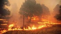
Following this advisory, the conditions for fire hazards are considered severe, especially west of Interstate 35. The forecast indicates extremely low humidity contributing to the heightened danger, as noted by Hernán Martínez, spokesperson for the Laredo Fire Department. “During this week, specifically due to high winds and warm temperatures, it is very dangerous to ignite anything, as it can start a fire,” he cautioned.
This situation corresponds with a red flag warning in place, indicating a combination of warm temperatures and strong winds, which increases fire risks considerably. Martínez remarked that a dryline’s presence is also exacerbating low humidity levels, further enhancing these hazardous conditions.
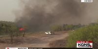
In the wake of these weather warnings, local fire incidents have increased. In addition to a fire registered at Laredo College on Monday, March 17, authorities have responded to multiple incidents last week, including one on Burnside Street and another on Geronimo Loop where a residence was substantially damaged, thankfully with no reported injuries associated with these fires.
“On Friday at 4 PM, we had a fire on Geronimo Loop, which spread quickly through a ravine due to high winds and low humidity,” Martínez explained.
Conditions remain conducive to fire jeopardy through the week with elevated fire dangers approaching critical levels. Weather forecasts predict a significant drop in temperatures into the high 60s following a cold front’s arrival. On Thursday, March 20, expected temperatures are between 41°F and 68°F. However, despite temporary cooler conditions, elevated fire dangers will persist into the weekend.
Additionally, the anticipated forecast outlines increasing temperatures into the 80s through the weekend, with climactic conditions returning Sunday, March 23. Insisting on community cooperation, fire authorities recommend avoiding specific activities that may incite fires. Their suggestions include not discarding cigarette butts in grassy areas, refraining from conducting any activities that generate flames, and avoiding parking near tall brush where hot exhaust pipes can spark a fire.
“The National Weather Service issues the ‘Red Flag Warning’ in collaboration with land management agencies to alert land managers about imminent fire weather patterns,” noted Yolanda Villarreal, weather presenter at KGNS+. “This alert is pivotal as it signifies that fire conditions are either ongoing or expected to occur imminently.”
The ramifications of these warnings could be some of the worst cases seen if they are not heeded, with many community members facing unnecessary hazards. “One way we can collectively prevent such fires,” Martínez adds, “is to ensure we extinguish all lit materials properly. No open flames should be left unattended.”
The ongoing weather condition analysis supports an assessment of this severe atmosphere around Laredo and beyond. Meteorologists anticipate that as the week's end approaches, storm chances may creep back near Interstate 35, yet the ongoing dry conditions should remain prevalent for a significant period.
Looking at the forecast for the next several days, here’s what residents can expect:
- Wednesday, March 19: Partly sunny with a low of 57°F and a high of 68°F.
- Thursday, March 20: Partly sunny with a low of 41°F and a high of 68°F.
- Friday, March 21: Partly cloudy with a low of 45°F and a high of 79°F.
- Saturday, March 22: Mostly sunny with a low of 51°F and a high of 81°F.
- Sunday, March 23: Partly cloudy with a low of 60°F and a high of 82°F.
- Monday, March 24: Sunny with a low of 53°F and a high of 76°F.
- Tuesday, March 25: Sunny with a low of 55°F and a high of 84°F.
- Wednesday, March 26: Partly sunny with a low of 56°F and a high of 83°F.
- Thursday, March 27: Partly cloudy with a low of 58°F and a high of 83°F.
- Friday, March 28: Partly cloudy with a low of 61°F and a high of 84°F.
As we continue to navigate these challenging weather patterns, the communities are urged to stay alert and take the preventive measures that fire officials have laid out. With the fluctuating weather, keeping property secure and fire-prone zones monitored is essential to minimize risks of wildfires.