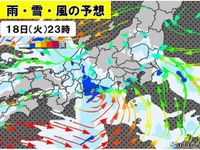
As the winter chill continues to grip Japan, a series of strong weather patterns are expected to sweep across the country over the coming days, particularly impacting the eastern regions. On March 18, 2025, the East Sea is set to face stormy conditions, with heavy rain and strong winds anticipated. Observers are advised to remain vigilant for potential thunderstorms and hail.
The disruption is directly linked to a low pressure system approaching from the west, promising to affect weather stability significantly. As of 2:00 PM on the 18th, rain and snow clouds had begun to blanket several regions, with particularly intense weather expected from Kyushu to Shikoku, and extending into the Chugoku region. Specifically, Shizuoka Prefecture is bracing for substantial snowfall, with reports indicating up to 10 cm predicted in the mountainous areas to the east and central parts.
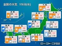
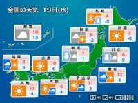
Looking ahead to March 19, forecasters predict that the storm will escalate, bringing erratic weather patterns from Kyushu all the way to Tohoku. The Japan Meteorological Agency has warned of particularly strong winds along the coastal areas, prompting concerns of heavy snowfalls especially in Kanto’s mountainous terrains and across the Pacific side of Tohoku. Snowfall totals could reach significant levels, with thunderstorm activity making conditions hazardous.
In the Kanto region, residents can expect cold rain and potential snow accumulation even in urban areas as weather systems shift. Caution is advised for the northern Kanto plains, where hazardous conditions might hinder travel due to ice and snow. Reports indicate that even metropolitan areas might see rain turning into snow, leading to hazardous road conditions.
In conjunction with these developments, the situation further deteriorates for the Tohoku region, where moist snow is anticipated to accumulate, leading to increased risks of traffic disruptions and damage to agricultural facilities due to heavy loads on roofs.
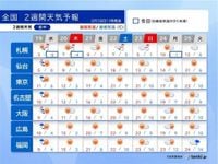
Looking beyond the immediate forecast, meteorologists note that after March 21, temperatures will begin to climb significantly. The weekend will herald a rise into the 20-degree Celsius range, marking an early entry into spring-like conditions. Forecasts suggest that by March 25, cities like Tokyo and Nagoya may register temperatures akin to late May, reaching upwards of 23 degrees Celsius, while Fukuoka could approach 24 degrees Celsius.
Notably, this anticipated warmth aligns with the cherry blossom season, fueling expectations that sakura blooms will appear earlier than usual in urban landscapes. The conditions could provide a beautiful backdrop for celebrating the onset of spring, with forecasts indicating that Tokyo and surrounding areas will likely witness full bloom by the end of the week.
Nonetheless, the weather pattern warns of occasional rainy days impacting outdoor plans post-March 26. While temperatures remain consistently high, fluctuating conditions could necessitate adjustments in plans, particularly for those hoping to enjoy cherry blossom viewings.
As of March 18, experts have been studying existing conditions, emphasizing that the surrounding cold air, combined with a powerful low pressure system, will yield unpredictable climatic phenomena. Residents are urged to remain aware of warnings and advisories regarding falling weather conditions and the emerging spring season.
With this complex interplay between winter and the onset of spring, travelers and locals alike must stay tuned for shifting weather patterns while being prepared for potential disruptions. The gradual march towards warmer climate should also be balanced with caution against residual winter weather anomalies which may linger in the East Sea region leading into the early days of spring.