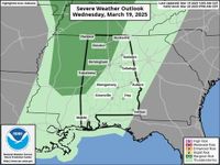
As severe weather looms over Alabama, the National Weather Service has issued warnings for today, March 19, forecasting a low risk for strong to severe storms in parts of north and west Alabama. According to forecasters, damaging winds and hail will be the primary hazards, while the likelihood of tornadoes in the area remains negligible.
The storms are predicted to approach the western part of Alabama between 4 and 6 p.m. and continue to push eastward throughout the night, though forecasters expect them to weaken upon arrival. The National Weather Service reported, "Damaging winds and hail will be the main hazards, and tornadoes are not expected." Residents are advised to remain vigilant.
Adding to the mix, wind advisories are in place for many counties in north and central Alabama. Wind gusts over the next few hours could reach 35–40 mph, making outdoor activities potentially hazardous. "Wind advisories for north and part of central Alabama will go into effect today," the National Weather Service added, alerting citizens to prepare for gusty conditions.
Following the storms, a cold front is set to descend upon the region, ushering in a significant drop in temperatures. By March 20, overnight lows are expected to plummet below freezing in parts of north and central Alabama. The National Weather Service highlighted the importance of this change, noting, "Low temperatures may fall below freezing in parts of north and central Alabama," posing a risk to new plantings and vulnerable vegetation in the area.
Today's high temperatures, on the other hand, will be a stark contrast, with many areas anticipating highs in the 70s and even 80s. However, the forecast indicates that March 20 will bring about cooler conditions, with highs only expected to reach the upper 40s to low 50s in northern parts of the state and only slightly warmer in central Alabama.
As the cold front sweeps through, residents in south Alabama can expect to see highs in the low 60s. The sudden shift in temperature is indeed noteworthy after the balmy weather of March 19.
In terms of nighttime weather, March 20 into March 21 will also see overnight lows dipping into the 30s statewide, with frost advisories anticipated for northern and central Alabama. This chilly blast could lead to significant impacts on any recently planted crops or young flora, urging residents to take precautions.
Looking ahead to the weekend, while March 23 brings the next chance of rain for Alabama, no severe weather is predicted. As conditions stabilize, it’s likely that the first part of next week will experience fairly quiet weather.
As always, Alabamians are encouraged to stay tuned for updates from the National Weather Service and utilize safety measures to protect themselves and property during this weather event.