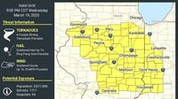
CHICAGO - A Tornado Watch is currently in effect for numerous counties across Illinois and Indiana, warning residents about the potential for severe weather this afternoon. The watch is valid until 9 p.m. and covers several counties in Illinois, including Grundy, Kendall, Kankakee, La Salle, and Will. Indiana counties under the watch include Newton, Benton, Warren, and Tippecanoe, among others.
As per the National Weather Service (NWS), hazardous conditions such as damaging wind gusts, tornadoes, and hail are in the forecast. Strong tornadoes are particularly concerning, with forecasts indicating ping-pong-sized hail and wind gusts reaching up to 70 miles per hour. The Storm Prediction Center (SPC) has reported a 10% risk of tornadoes south of Interstate 88 and a 5% risk for the wider Chicago area.
Nearly 2 million people in regions south of Chicago are bracing for potentially severe weather, according to the SPC’s severe thunderstorm risk scale, which ranks this as a level 3 out of 5 risk zone. Cities such as Peoria, Decatur, and Champaign are included in this alert. Weather experts caution that residents should remain vigilant and prepared as conditions develop.
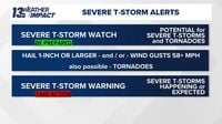
Many may be wondering about the differences between a severe thunderstorm watch and a warning. As articulated by the 13 Weather Impact Team, a thunderstorm watch means that conditions are ripe for severe weather to form, urging people to stay alert. A warning, conversely, indicates that severe weather is either happening or imminent, with residents advised to take shelter immediately.
This week marks Severe Weather Awareness Week in Michigan, where educational efforts are underway to increase public understanding of severe weather risks. Historically, Michigan's peak severe weather season runs from spring into early summer, when warming temperatures and moisture create an environment conducive to severe thunderstorms.
The 13 Weather Impact Team has been providing daily updates and insights to help audiences understand how to navigate severe weather alerts effectively. One engaging educational effort likens the difference between a watch and a warning to food – specifically tacos. When you have a "taco watch," the ingredients are present, but the taco hasn't been made yet; conversely, a "taco warning" means the taco is complete and ready to eat. This analogy emphasizes how a tornado watch represents favorable conditions for tornadoes, while a warning signifies that a tornado is imminent and confirmed.
Further emphasizing public safety, the NWS introduced damage tags to their severe thunderstorm warnings in 2021. For example, a "base" severe thunderstorm warning indicates radar-indicated winds of at least 58 mph and/or hail of one inch in diameter. Should damaging winds exceed 70 mph or hail reach 1.75 inches, a "considerable" tag will be attached to the warning, alerting residents of significant hazards.
A "destructive" tag is also used when winds exceed 80 mph and hail reaches sizes of 2.75 inches, comparable to a baseball. In such cases, a Wireless Emergency Alert (WEA) will be triggered on cell phones, prompting immediate attention. The NWS has stated that this tag is designed to convey the urgency for the public to take immediate action, as life-threatening events could occur.
As severe storms are predicted across the Midwest today, residents in affected areas are encouraged to stay updated with the latest forecasts from the NWS and local weather services. Understanding the difference between a watch and a warning, and acting accordingly, could potentially save lives and mitigate risks during severe weather.
Every individual should be taking these alerts seriously. With conditions changing rapidly this time of year, remaining informed is key. As the 13 Weather Impact Team noted, during watches, individuals should stay weather aware—monitoring sky conditions and having a safety plan in place is paramount.
The ongoing tornado watch emphasizes the need for preparedness while the public is reminded of the importance of heeding the NWS advisories. Knowing the difference between a severe thunderstorm watch and a warning—as well as understanding what conditions lie in wait—could be the difference in protecting oneself and loved ones during this hazardous weather season.