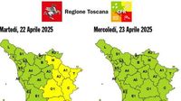
Weather alerts have been issued across Italy as unstable conditions are expected to persist in the coming days. On Tuesday, April 22, 2025, a yellow alert for strong rain and thunderstorms was announced for several regions, including Mugello, Valdarno superiore, Casentino, Valtiberina, Valdichiana, and the basins of Fiora and Ombrone grossetano, effective from 2 PM to 7 PM. The regional civil protection office has warned of hydrogeological and hydraulic risks, particularly affecting the minor network in these areas.
According to the regional authorities, the Mugello area has already faced severe weather conditions in mid-March, with ongoing repairs still in progress. The situation remains unstable, with forecasts predicting precipitation and thunderstorms starting in the afternoon. The Meteorological Service indicated that instability would particularly impact Mugello and the mountainous regions of eastern Tuscany.
Following this alert, the weather conditions are expected to worsen further. The Functional Monitoring Center for Natural Risks of the Lombardy Region announced a yellow weather alert for hydrogeological risk and thunderstorms, which will be in effect from midnight on Wednesday, April 23, until midnight on Thursday, April 24, 2025. This alert covers Milan and the entire Lombardy region, prompting local authorities to advise citizens to exercise caution in areas prone to flooding and to secure any outdoor items that could be affected by strong winds and rain.
The Municipality of Milan also emphasized the importance of avoiding standing under trees or near construction sites during this period. The municipal operations center (COC) will be active to monitor the situation and coordinate any necessary interventions.
In Bologna, the Civil Protection has extended the yellow alert for thunderstorms and river floods for another 24 hours, now covering the entire Bologna area. The latest bulletin from the ARPAE indicates favorable conditions for the development of intense thunderstorms, which could lead to significant effects and damage. The region is also warned of possible runoff and landslides in the Apennines and hills due to the rains.
As the weather system moves across the country, meteorologist Lorenzo Tedici stated that no high-pressure system is currently in place to provide stable and sunny weather. This situation is expected to continue for the next 6-7 days. A low-pressure area from the British Isles is set to arrive, bringing with it more unstable weather patterns, including the potential for thunderstorms and hail.
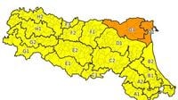
On Wednesday, April 23, the day will begin with mostly stable weather, but instability is expected to increase in the afternoon. The new disturbance will bring scattered rains, initially affecting the northern regions before spreading to the center and parts of the south by the end of the day. The Civil Protection Department has issued an orange alert for Emilia Romagna, Veneto, and Lombardy due to hydraulic risks, while a yellow alert has been issued for several other regions.
In terms of specific alerts, the orange alert indicates moderate criticality for hydraulic risk in Emilia Romagna (Ferrara coast and plain), Lombardy (lower eastern plain), and Veneto (Po, Fissero-Tartaro-Canalbianco, and Basso Adige). Meanwhile, ordinary criticality for hydraulic risk has been indicated in various regions, including Calabria, Emilia Romagna, and Lombardy.
As for the weather forecast, conditions on Wednesday are expected to be characterized by variability, with a mix of sun and clouds across most of Italy. During the central hours of the day, the risk of sudden showers and thunderstorms will increase, particularly affecting the Alps, the Lombardy-Veneto plain, Emilia, and other internal areas of Central Italy. Maximum temperatures will be slightly lower but will remain above normal in many areas.
In addition, winds are expected to blow moderately, especially over the western seas and around major islands, with an intensification anticipated in the evening. The forecast suggests that while the bad weather may persist initially, sunnier days are likely to follow.
As the situation develops, residents are urged to stay informed and prepared for possible changes in weather conditions. The Civil Protection agencies across the regions are actively monitoring the forecasts and will provide updates as necessary.