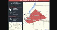
WILL COUNTY, IL — Severe weather swept across Illinois on March 19, 2025, prompting multiple tornado warnings and watches from the National Weather Service. As storms developed in the region, warnings were issued until 5:30 p.m. for communities including Joliet, New Lenox, Homer Glen, Mokena, Tinley Park, Orland Park, Frankfort, and Frankfort Square, with a tornado indicated on radar.
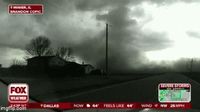
A severe storm capable of producing a tornado was located over Ingalls Park near New Lenox, moving northeast at a swift 50 mph. The National Weather Service reported the possibility of pea-sized hail accompanying the tornado warning, intensifying concerns in the area.
As the weather system progressed, a tornado watch extended across Kendall, Kankakee, Grundy, and Will counties—encompassing most of central Illinois—lasting until 9 p.m. on the same day. The weather service noted that scattered storms could become severe, stating, "A few tornadoes may occur, especially along and south of I-80, possibly as far north as I-88.” This created a level 3 out of 5 tornado risk for the region, highlighting the seriousness of the situation.
The afternoon's forecast warned of damaging winds, hail, and additional tornado threats, particularly between 3 and 8 p.m. that day. "Flying debris will be dangerous to those caught without shelter. Mobile homes will be damaged or destroyed," the National Weather Service stated, urging residents to seek cover immediately.
The weather chaos was not limited to northeastern Illinois. A powerful winter storm also affected surrounding areas, leading to a Tornado Watch in northern and central Illinois and western Indiana, extending into southern Illinois and central Kentucky. Reports detailed a tornado spotted near Stanford, Illinois, as severe storms charged across the state southeast of Peoria.
As the storm approached, the SPC placed nearly 53 million people across the Midwest and into the Deep South under its threat zone for severe thunderstorms. The severe weather alert warned of strong winds and potential tornado formations with sustained thunderstorm activity anticipated to commence by afternoon. Along the way, a 74 mph wind gust was recorded in Lincoln, with power outages reported in Nebraska, Kansas, and Iowa as blizzard conditions persisted in those regions.
Despite the warnings, initial assessments indicated that the Peoria County Director of Emergency Management, R. Jason Marks, reported no significant storm damage had been detected by local weather spotters. This observation marked a sigh of relief amidst the heightened threat levels as officials continued to evaluate conditions in Tazewell, Woodford, and Fulton counties.
Thunderstorms continued to develop and strengthen into the evening as the National Weather Service provided ongoing updates regarding the severe weather’s trajectory toward eastern Illinois. As night approached, the tornado watch was lifted, yet vigilance remained necessary for all residents due to ongoing severe weather risks.
Once the severe weather moved out, meteorologists predicted a shift to “wind-whipped wet snow” overnight into March 20. Slushy accumulations were anticipated as the remnants of the intense storm system transitioned across the region.
In summary, the weather events of March 19, 2025, displayed the unpredictable nature of spring storms in Illinois, bringing swift tornado warnings and damaging storm conditions followed by a sudden change to winter-like weather. Residents are urged to stay alert and prepared as changing conditions can pose renewed threats even after warnings have expired.