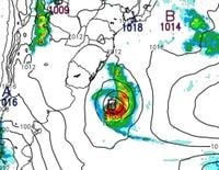
The first extratropical cyclone of the fall season is set to bring significant weather changes to Rio Grande do Sul starting Thursday, March 27, 2025. Meteorologists from MetSul are predicting a low-pressure system that will unleash heavy rain, strong winds, and the potential for hail across the region.
As the cyclone begins to develop, it will first impact the western parts of the state, with rain expected to arrive in the early morning hours. This system is characterized by large vertical development clouds, which pose a risk for storm cells that could lead to severe weather conditions throughout the day.
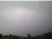
According to the forecasts, the rain will be irregular but could lead to substantial accumulations between 50 mm and 100 mm, especially in the Western Half of Rio Grande do Sul. The storms are anticipated to spread across the territory, with the potential for strong gusts of wind exceeding 100 km/h. The risk of localized hail and flooding in urban areas has also been highlighted.
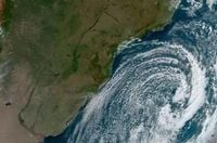
On Friday, March 28, a second wave of storms is expected, particularly affecting the West and Northwest regions of the state, especially near the border with Argentina. These storms may bring moderate to heavy rain, lightning, and additional occurrences of hail. Areas between Campanha and Zona Sul should remain vigilant, as strong winds are forecasted to occur.
As the cyclone moves into the Atlantic Ocean by Saturday, March 29, it is expected to quickly move away from the coastline, leading to a gradual improvement in weather conditions. The forecast predicts a predominance of dry air with sunny skies and rising temperatures across the northern parts of the state.
The Municipal Civil Defense in Porto Alegre has issued a warning for heavy rain, gusts of wind reaching up to 50 km/h, electrical discharges, and the possibility of hail between the afternoon of Thursday and the night of Friday. Accumulations in the city could reach up to 40 mm, with the most intense weather likely occurring on Thursday night.
Residents are advised to avoid flooded areas and seek shelter during the storms. The Civil Defense recommends that those living in vulnerable areas take precautions, including staying away from trees, power lines, and other structures that could be affected by strong winds.
In terms of temperature, Thursday in Porto Alegre is expected to start with cloudy skies and a minimum of 21°C, reaching a maximum of 27°C. The following day, Friday, will see isolated rain with temperatures ranging from a minimum of 20°C to a maximum of 23°C. By Saturday, the weather is expected to clear, with temperatures between 20°C and 25°C. Sunday will bring further sunshine, with temperatures potentially reaching 30°C.
As the weather unfolds, residents are urged to stay informed through local meteorological updates and heed any warnings issued by the authorities. The situation remains dynamic, and conditions may change rapidly as the cyclone progresses.
In summary, the upcoming days will be marked by significant weather events as the first extratropical cyclone of the season approaches Rio Grande do Sul. With heavy rain, strong winds, and the potential for hail, residents must remain vigilant and prepared for possible severe weather impacts.