On the evening of June 5, 2025, residents across the South Plains region of Texas faced a night of intense and potentially devastating weather as severe thunderstorms and tornadoes swept through the area. The National Weather Service (NWS) in Lubbock issued a series of warnings and watches throughout the day and evening, prompting emergency responses and widespread alerts.
The day was marked by a Tornado Watch covering a vast swath of counties including Bailey, Briscoe, Castro, Childress, Cochran, Cottle, Crosby, Dickens, Floyd, Garza, Hale, Hall, Hockley, Kent, King, Lamb, Lubbock, Lynn, Motley, Parmer, Stonewall, Swisher, Terry, and Yoakum. This watch was in effect until 10:00 p.m. and indicated the heightened risk of tornado formation across these areas.
Severe Thunderstorm Warnings were issued for several counties at different times, with Bailey and Cochran counties under warning until 5:45 p.m. Winds reaching speeds of up to 60 miles per hour and hail as large as 2.75 inches in diameter were expected. The NWS confirmed a large and extremely dangerous tornado near Maple, four miles southeast of the town, moving east at 20 miles per hour. This tornado was also located seven miles northwest of Morton, underscoring the broad area affected.
Additional Tornado Warnings extended through the evening for Bailey and Hale counties until 7:00 p.m., Lamb and Hockley counties until 7:00 p.m., and later for Hockley and Lubbock counties with warnings lasting until 7:45 p.m. and then extended further until 8:45 p.m. The progression of these warnings reflected the storm’s eastward movement at around 25 miles per hour, with particular concern for the Lubbock area and Texas Tech University, which was directly in the storm’s path.
At approximately 8:25 p.m., a tornado was reported near Reese Center, and a thunderstorm capable of producing a tornado was observed four miles northeast of Lubbock, moving over the downtown area. The storm was predicted to reach Lubbock by 8:30 p.m. Simultaneously, large hail was reported in Wolfforth, adding to the severe weather threats facing the region.
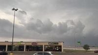
In response to the escalating threat, the City of Lubbock activated tornado sirens on Thursday evening, urging residents to seek immediate shelter. The sirens’ activation was a critical alert as Lubbock County was officially placed under a tornado warning by the NWS, emphasizing the urgency of the situation.
Emergency management officials in Hockley County took proactive measures by opening school facilities as designated storm shelters. Locations such as Levelland High School (north doors), Anton School (Door #25), Smyer School (doors under awning), Ropes School (Door 1-4), Sundown School (Door 14), and Whitharral School (Door 29) were made available to residents seeking refuge from the severe weather.
Alongside tornado warnings, flash flood warnings were issued for Hockley County until 10:00 p.m. and for Lubbock until 10:15 p.m., reflecting the heavy rainfall accompanying the storms. Severe Thunderstorm Warnings remained in effect for Crosby, Garza, Lubbock, and Lynn counties until 9:30 p.m., indicating the persistent threat of damaging winds and hail.
Throughout the evening, Texas Tech University kept its community informed, releasing a statement at 8:45 p.m. confirming the ongoing severe weather situation. Earlier, at 8:36 p.m., local news outlet KCBD reported the expiration of the tornado warning but noted that a severe thunderstorm warning remained in place, underscoring the continuing risk posed by the storms.
The National Weather Service’s detailed tracking and timely warnings were instrumental in alerting residents to the dangers posed by the rapidly changing weather conditions. Their updates highlighted the storm’s movement eastward at 25 mph, directly over Texas Tech and the Lubbock area, emphasizing the need for vigilance and preparedness.
As the storms passed, the South Plains region faced the aftermath of a severe weather event that tested the resilience of its communities. The combination of tornadoes, large hail, damaging winds, and flash flooding created a multifaceted threat that required coordinated emergency response and public cooperation.
The activation of tornado sirens, the opening of school shelters, and the continuous flow of information from the National Weather Service and local authorities illustrate the region’s commitment to public safety in the face of natural disasters. While the tornado warnings expired by late evening, the severe thunderstorm and flash flood warnings persisted, reminding residents that the threat was not yet fully over.
In the wake of the storms, recovery and assessment efforts would be crucial to understand the full impact on homes, infrastructure, and lives. The events of June 5, 2025, serve as a stark reminder of the power of nature and the importance of readiness in tornado-prone regions like the South Plains of Texas.