PADUCAH, Ky. (WSIL) -- Rampant tornado activity swept across southern Illinois and southeastern Missouri on the night of March 14 and the morning of March 15, 2025, leaving behind significant devastation and loss of life. The National Weather Service (NWS) has been diligently surveying the aftermath of these severe storms, which have been classified with varying levels of intensity.
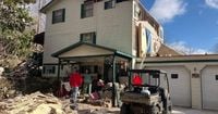
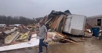
One of the most destructive tornadoes struck the Poplar Bluff area late Friday night. Preliminary assessments suggest this tornado reached EF-3 status, with recorded wind speeds peaking at 138 mph. It wreaked havoc on numerous homes, businesses, and other structures, claiming at least one life and leaving several others injured. The NWS reported extensive damage, particularly to a mobile home park located just west of Poplar Bluff along Highway PP. Other affected locations within the city and county included multiple businesses, as well as the local Kindergarten Center and community churches.
According to local reports, the devastation continued to escalate with each passing hour. The Black River Coliseum was turned to as a refuge for those displaced, providing shelter and resources to those urgently needing assistance.
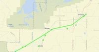
Simultaneously, tornadoes struck Du Quoin and Johnson County, Illinois. On March 15, officials confirmed damage from tornado activity, particularly focusing on structural damages to homes and uprooted trees. According to the reports from WSIL, the tornadoes caused significant damage across these regions, leaving survivors grappling with the immediate aftermath.
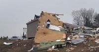
Further investigations revealed the tornado path near Puxico, Missouri, where another EF-1 tornado was observed. This tornado formed late on March 14, with wind speeds of about 95 mph. The NWS indicated the tornado tracked northeast for about 6.3 miles, hitting at 11:50 p.m. and concluding at 11:57 p.m. It damaged several homes, leading to roof and gutter destruction and impacting structures along County Road 404. These findings highlight the range of tornado severities affecting the local areas.
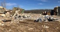
The NWS also focused on the significant damage reported across Carter and Wayne counties. During surveys following the storms, evidence pointed to another EF-3 tornado, which compounded the devastation over its long path. Beginning near Eastwood at 10:28 p.m. on March 14, this tornado traveled 24.4 miles, ending just northeast of Leeper at 10:56 p.m. and achieving wind speeds of 165 mph - the highest recorded from this storm system. Witnesses noted the tornado's width at its peak was around 400 yards, indicating the immense power it contained.
The weather service's thorough inspection of the damage also found earlier tornado activity in Carter County. A preliminary report indicated another EF-3 tornado recorded starting at 9:51 p.m. and traveling 17.5 miles before ceasing around 10:11 p.m., demonstrating the extensive impact of these weather patterns on local communities.
Authorities and weather officials stand vigilant, continuing to survey additional potential tornado tracks through the region. The challenges presented by these severe weather events necessitate heightened awareness and readiness among residents, as the local community dives headfirst to recover from these harrowing disasters.
The emotional toll of the loss and destruction is not lost on the affected residents. Local leaders are calling for solidarity as they navigate the aftermath, urging community support, outreach programs, and recovery efforts to aid those impacted significantly by this natural calamity.
Survivors are left to piece together their lives after Mother Nature's catastrophic display. “The feeling of vulnerability is overwhelming,” expressed one local resident. “Our homes and our memories have taken such damage, and it feels surreal to think about rebuilding.”
Despite the destruction, stories of resilience and hope emerge. Community members are banding together, sharing resources and providing support wherever needed. Neighborhood initiatives are forming to restore homes and help each other recover, reinforcing the idea of unity through adversity. An outpour of donations and supplies flows to the affected regions, showcasing the strong spirit of collaboration and cooperation among neighbors.
Heavy rain and severe winds are increasingly common challenges faced by residents of southern Illinois and southeastern Missouri. These tornadoes have underscored the urgency of preparedness and improved response strategies to safeguard lives and property moving forward. The reconstruction phase, expected to take considerable time and resources, has already begun as individuals and families rally to restore their communities once again.
Weather officials stress the importance of heeding warnings during severe weather incidents, emphasizing how quickly conditions can change. Understanding tornado preparedness and response can be life-saving. Education and resources will play integral roles as communities prioritize safety and bolster their resilience against future storms.
Through the chaos, the determination of the local populace proves undeterred. Recovery may take time, but the spirit of community support will remain the cornerstone of rebuilding lives and infrastructure following these tragic storms.