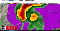
A tornado warning remains in effect for Parker and Palo Pinto counties until 11:15 p.m. and Wise County until 11:30 p.m. At 10:49 p.m. on April 19, 2025, a severe storm capable of producing a tornado was located near Cool, approximately seven miles southeast of Mineral Wells, moving northeast at 35 mph. The storm is expected to reach Springtown around 11:20 p.m. Other areas that may be impacted include Adell, Peaster, Whitt, Advance, Agnes, Bennett, Authon, Garner, Millsap, and Sanctuary.
Just after 10 p.m. on April 19, 2025, a tornado was reported just south of Weatherford. The storm is expected to reach Weatherford around 10:20 p.m. and Poolville around 10:40 p.m. At 10:23 p.m., reports indicated two tornadoes on the ground north of Weatherford. The affected area includes I-20 between mile markers 401 and 412, according to the National Weather Service.
Severe weather capable of producing tornadoes was located seven miles southwest of Poolville or 10 miles northwest of Mineral Wells, moving northeast at 30 mph. At 9:50 p.m., a tornado watch was issued for Comanche, Cooke, Denton, Eastland, Erath, Grayson, Hood, Montague, Palo Pinto, and Somervell counties until midnight on April 19, 2025. The National Weather Service reports that a storm spotter saw trees down, powerlines down, and mobile homes damaged in Tolar.
At 9:45 p.m., two apparent tornadoes were reported in Parker County — one north of Cool and one northeast of Lipan. At 9:20 p.m., a severe thunderstorm capable of producing a tornado was located eight miles southwest of Cool or eight miles south of Mineral Wells. Radar has indicated rotation. In addition to Cool, Lake Mineral Wells, and Poolville, other affected locations include Brock, Junction, Adell, Peaster, Whitt, Advance, Agnes, Bennett, Authon, Garner, and Millsap.
According to a summary provided by the National Weather Service as of 9:30 p.m.: - Flash Flood Warning: Montague and Jack counties are experiencing significant flooding. - Severe Thunderstorm Warning: Montague and Cooke counties are facing 70 mph winds and ping pong ball-sized hail. - Ongoing Tornado: Hood County, between Lipan and Oak Trail Shores, moving north into Parker County. - Possible Tornado: Palo Pinto/Parker County line, north of Bennett, moving north towards Cool.
A tornado warning remained in effect for Hood County until 9:30 p.m. At least two tornadoes were spotted in Hood County, just west of Granbury. At 8:45 p.m., the tornado warning was extended to include northeastern Erath County and Hood County. A severe thunderstorm capable of producing a tornado was located eight miles south of Bluff Dale or 11 miles east of Stephenville, moving northeast at 35 mph. The storm presents a threat of a tornado and quarter-size hail.
Additional areas affected by the tornadic thunderstorm include Tolar, Lake Granbury, Stockton Bend, Waples, Paluxy, and Johnsville. At 8:20 p.m., a severe thunderstorm capable of producing a tornado was located near Hico, 13 miles southeast of Stephenville, moving northeast at 35 mph. Radar indicated strong rotation in Erath County northeast of Clairette, approaching Highway 235 just east of Highway 281. The tornadic thunderstorm is expected to remain in rural areas of Somervell, eastern Erath, and southwestern Hood counties, including Alexander, Clairette, Rainbow, Johnsville, Paluxy, Seldan, Chalk Mountain, Duffau, and Nemo.
Meanwhile, Montague and Cooke counties remained under a tornado warning until 8:30 p.m. as a confirmed tornado that started near Jacksboro continues to move northeast. At 7:48 p.m., a tornado was trying to form near St. Jo and Nocona. At 7:11 p.m., a severe thunderstorm capable of producing a tornado was located near Bowie, moving northeast at 35 mph. At 7:06 p.m., a storm watcher reported a tornado crossing Highway 287 at Fruitland near Sunset and Bowie.
At 6:57 p.m., two rotations were seen on radar near Highway 287 in the vicinity of Sunset and Bowie. As of 6:35 p.m., outdoor warning sirens were sounding in Bowie. At 6:32 p.m., Jack County emergency officials reported a tornado on the ground near the intersection of Highway 59 and FM 1810. Stay alert and take cover immediately if you are in the affected areas.
North Texas is in for a wet and soggy weekend, which might put a damper on Easter weekend plans. On Saturday afternoon, a powerful tornado supercell swept north of San Angelo, leaving residents on high alert. As the evening progresses, several clusters of storms are advancing from the southwest, heading directly towards our watch area.
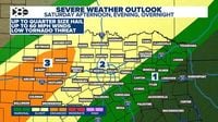
Meteorologists warn that these storms could bring large hail, with sizes exceeding 2 inches, posing significant risks to property and safety. As the evening approaches, residents of the Metroplex should brace for the arrival of severe storms. This will be the first wave of storms, expected to hit between now and mid-morning tomorrow. These storms carry the highest threat of severe weather, including large hail, isolated tornadoes, and flooding rain.
The severe threat should start to ramp down overnight. Strong storms with heavy rain are expected overnight into Sunday morning. Earlier this morning, we experienced a round of severe weather and heavy rain. The northwest corner logged rainfall amounts between 1 and 2 inches. A Flood Watch remains in effect for this area until Sunday morning.
On Easter Sunday, North Texas has a high chance of showers and storms during the early morning hours, bringing a flood threat as a cold front moves through. However, by the time it reaches mid-morning and early afternoon, most of those showers start to push out to the east. As the afternoon hours approach, expect some sun as the cold front will have moved through the area. Temperatures start in the lower 60s during the morning, then head to the mid-70s during the afternoon.
Timeline for severe weather chances in North Texas Saturday morning: - Several rounds of storms - Chance of large hail and damaging winds Saturday night: - Heaviest rain arrives - elevated flood risk Easter Sunday early morning: - Heavy rain, with training storms - Elevated flood risk Easter Sunday mid-morning: - Storms move to the east of DFW. CBS News Texas will be tracking the storms all weekend long. Download the CBS News app and search for the "Texas" section.