LOUISVILLE, Ky. (WDRB) -- The National Weather Service confirmed significant tornado activity over the weekend as four tornadoes touched down across southern Indiana between Friday night and Saturday morning, March 14-15, 2025. The weather disturbances led to damage, but fortunately, no injuries were reported.
On Sunday, March 16, the National Weather Service reported the first incident, identifying it as an EF1 tornado. This specific tornado traversed northern Orange County, Indiana, stretching from West Baden Springs to Orleans. It had peak wind speeds reaching up to 110 miles per hour as of the assessment concluded on the evening of March 17.
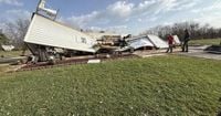
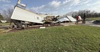
Wilting trees and damaged structures underscored the tornado's destructive path. The tornado made landfall just before dawn at approximately 4:45 AM and was on the ground for about eight minutes, lifting at 4:53 AM. It covered a significant distance estimated at 11.02 miles.
According to the NWS, the tornado's path initiated around West Sinclair Street, where witnesses reported trees snapped approximately 20 feet above ground level. The effects were visible as the tornado progressed, with significant damage around rural portions of West Baden Springs and Orleans.
A second EF1 tornado was confirmed south of Brownstown, Indiana, on Monday, March 17, with estimated wind speeds of 105 miles per hour. This tornado contributed to the total count of four, alongside two additional EF0 tornadoes recorded later, one registering 75 miles per hour and the other at 85 miles per hour. Both EF0 tornadoes were reported to have touched down northwest of Bedford, Indiana, within Lawrence County.
The extensive survey undertaken by the National Weather Service continues, as officials analyze the impact areas. The EF1 tornado, noted for its 50-yard width at its largest extent, caused wind damage primarily through downed trees and compromised infrastructure.
Images from the storm damage depict devastation with trees uprooted, power lines down, and residential properties affected. Fortunately, throughout these extreme weather events, there were no fatalities or severe injuries reported.
Residents described the moment of the tornado's approach with trepidation. Reports indicated the strong winds were so powerful they could be heard roaring as the tornado moved through neighborhoods, creating moments of panic for those nearby.
Damage estimates are anticipated to grow as survey teams conduct additional inspections. Reports highlight the need for caution as storms continue to develop across the region, emphasizing the unpredictability of severe weather conditions.
With the recent tornado activity drawing attention, emergency management officials have reiterated the importance of community preparedness and awareness. This storm serves as a reminder of the potential damages associated with tornado activity.
Mark Weinberg of WDRB tweeted, “The NWS has confirmed 4 tornadoes touched down throughout the area on Friday night and early Saturday morning.” With such intense conditions prompting quick reactions from local authorities and disaster preparedness teams, mitigation plans may need reevaluation to address future storms.
Officials stress the necessity for residents to remain informed during severe weather events to safeguard lives and property.
The recent outbreak of tornadoes and severe weather patterns has raised concerns within the community about infrastructure resilience against such extreme weather. Residents are urged to stay aware of the forecasts and potential warnings to minimize risks associated with future occurrences.
Despite the harrowing experiences, local communities displayed resilience, coming together to support one another. The public response to the storms underscored the strength of community bonds, as neighbors helped with clean-up and recovery efforts, emphasizing the spirit of cooperation and assistance during crises.
This event highlights the necessity for continuous vigilance and adaptation to changing weather patterns and the impacts of climate change on regional weather occurrences.
The National Weather Service is expected to continue monitoring the situation and assessing damage. Their detailed findings will inform future preparedness and response strategies for the residents of southern Indiana.
Authorities will communicate updates as new information arises from the NWS and emergency management teams. Community meetings and discussions will be held to address safety concerns and assess recovery needs going forward.