Severe thunderstorms have unleashed chaos across the central and eastern United States, prompting life-threatening flooding and damaging winds. As of April 29, 2025, over 50 million people are at risk from these storms, with warnings in effect across multiple states.
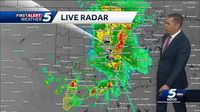
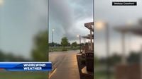
The storms, which began on April 28, brought with them fierce winds, hail larger than baseballs, and tornadoes. The National Weather Service issued severe thunderstorm warnings across six states and a flash flood warning specifically for Oklahoma City as heavy rain and strong winds continued to pose threats.
According to the Storm Prediction Center, a massive 1,800-mile stretch from West Texas to Vermont is under a level 2-of-5 risk for severe thunderstorms. More concerning are the areas in Ohio, Pennsylvania, New York, Texas, and Oklahoma, which are experiencing a heightened level 3-of-5 risk.
On Tuesday morning, powerful storms swept through areas from northern Texas to southern Kansas and then continued east into Missouri, where a line of storms in southwestern Missouri recorded wind gusts up to 90 mph and produced several brief tornadoes in nearby regions. The impact of these storms has left over 60,000 homes and businesses without power in Missouri alone.
As the day progressed, additional strong to severe storms developed in Oklahoma and Arkansas, while areas in Indiana and Ohio faced wind gusts reaching 70 mph, resulting in over 50,000 customers losing power late Tuesday afternoon.
Forecasters warned that the threat of flooding remains significant, particularly in northern Texas and much of Oklahoma, including Oklahoma City and Tulsa, where a level 3-of-4 risk of flooding rain is currently in effect. This risk is compounded by the fact that the ground has already been saturated from previous storms, making it unable to absorb more moisture.
In Oklahoma, the situation is dire. Flash flooding from storms over the weekend had already prompted high-water rescues and resulted in at least five fatalities. As of Tuesday morning, flash flooding was already occurring in the Oklahoma City area, with forecasts predicting that conditions would worsen as more storms hit the region.
Southwest Oklahoma is particularly at risk, with the National Weather Service warning of “locally catastrophic” flooding. The storms are also moving northward, affecting parts of Ohio, Pennsylvania, New York, and even reaching as far as Ontario, Canada, where damaging wind gusts and hail could be expected.
Looking ahead, a level 3-of-4 risk of flooding rainfall is in place for parts of Texas, Oklahoma, Missouri, and Arkansas on Wednesday, April 30, 2025. Although the widespread chances of damaging storms will decrease later in the week, the potential for severe weather remains.
As the storms have developed, the National Weather Service has issued numerous flash flood warnings across several counties. In Oklahoma, flash flood warnings have been issued for Cleveland, Garvin, Lincoln, McClain, Pontotoc, Pottawatomie, and Seminole counties until early Wednesday morning.
Reports of flooding have already emerged from various locations. Streets in Purcell were inundated with water, and I-35 northbound at I-44 in Oklahoma City was shut down due to flooding. In Norman, flooding on Lindsey Street has been reported, and a creek in Moore is completely full from the heavy rainfall.
The flash flood warnings have been upgraded to considerable, which could trigger alerts on residents’ phones. As heavy rain continues to fall in the metro area and south toward I-35, additional storms are expected to return around 3 a.m. Wednesday, bringing another wave of flooding risk.
The severe weather system has prompted officials to urge residents to avoid driving through flooded roadways and to be prepared for potential evacuation if necessary. The National Weather Service has consistently reminded the public: “Don’t drive on flooded roadways. Turn Around Don’t Drown!”
As the storms continue to develop, meteorologists are monitoring the situation closely. The latest updates indicate that parts of Oklahoma may see an additional 2 to 4 inches of rain on top of what has already fallen, exacerbating the flooding threat.
Despite the severe weather conditions, many residents remain vigilant and prepared, relying on local news and weather services for updates and guidance. The situation continues to evolve, and officials are urging everyone in affected areas to stay alert and take necessary precautions.
In summary, the severe thunderstorms affecting the central and eastern United States present a serious threat to millions. With flooding, damaging winds, and tornadoes all possible, residents are encouraged to stay informed and heed warnings from local authorities.