Severe thunderstorms swept through southeastern Wisconsin on the morning of April 18, 2025, prompting multiple warnings from the National Weather Service (NWS). The storms, which produced large hail and damaging winds, affected several counties, including Milwaukee, Ozaukee, Waukesha, and Jefferson.
At 8:10 AM, the NWS issued a Severe Thunderstorm Warning that was in effect until 9:00 AM for Ozaukee, Milwaukee, Dodge, Jefferson, and Waukesha Counties. The storms were reported to be moving east at a rapid pace of 65 miles per hour, with half dollar-sized hail noted in some areas. Locations such as Milwaukee, Pewaukee, Wales, and UW-Milwaukee were among those impacted.
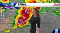
Earlier, at 7:17 AM, another warning had been issued for a line of severe thunderstorms stretching from Juneau to Lac La Belle to Milton, where the storms were moving even faster at 75 miles per hour. Potential hazards included destructive two-inch hail and wind gusts reaching 60 miles per hour. The NWS cautioned that people and animals outdoors could be injured, and significant damage could occur to roofs, siding, windows, and vehicles.
The situation escalated further when reports of baseball-sized hail emerged from a storm located near Edgerton, Wisconsin, moving east at 65 mph. This storm was part of a larger system affecting Southern Jefferson County and southwestern Dodge County, with a warning in effect until 7:45 AM.
As the storms progressed, Milwaukee was placed under a flash flood warning due to the heavy rainfall associated with the thunderstorms. This warning was effective until 11:45 AM and covered Milwaukee, Ozaukee, and Waukesha counties. Meteorologist Marcia Cronce from the NWS indicated that residents should expect flooding in small creeks, streams, urban areas, and highways. Drivers were advised to be cautious of lane closures due to flooding, particularly on Interstate 41/45 South at Burleigh Street.
Reports from various sources indicated that tennis ball-sized hail was observed in other parts of the state, with social media posts showcasing damage done to vehicles in Evansville, Wisconsin. Video footage captured by TMJ4 News showed significant flooding in Milwaukee, particularly at the intersection of 20th and Capitol.
In light of the severe weather, the NWS emphasized the importance of seeking shelter inside well-built structures and staying away from windows. "Prepare immediately for large hail and deadly cloud-to-ground lightning," the NWS warned.
As the morning storms passed, forecasters predicted additional severe weather in the afternoon and evening across southeastern Wisconsin. The potential for further strong thunderstorms could lead to more hazardous conditions, depending on whether the sun emerged to heat the atmosphere.
The severe thunderstorm warnings and flash flood warnings are part of a broader pattern of unpredictable spring weather that has characterized the region in recent years. Residents are reminded to stay informed through local news outlets and the NWS for updates on weather conditions.
With the ongoing threat of severe weather, the community is urged to remain vigilant and prepared for potential emergencies. The NWS continues to monitor the situation closely, providing updates as new information becomes available.