Severe thunderstorm warnings were issued and a tornado watch was in effect for parts of Oklahoma as storms tracked across the state early Saturday morning, April 19, 2025. The National Weather Service (NWS) has been actively monitoring and issuing alerts as conditions developed.
At 12:50 a.m., the NWS issued a severe thunderstorm warning for southern Seminole County, northeastern Pontotoc County, and central Hughes County, primarily due to the threat of quarter-sized hail. This warning was set to expire at 1:30 a.m. The affected areas included Allen, Dustin, Calvin, Lamar, Horntown, and Atwood.
Just minutes earlier, at 12:45 a.m., a tornado watch remained in effect until 4 a.m. for several counties, including Pottawatomie, Pontotoc, Seminole, Atoka, Coal, Hughes, Johnston, Marshall, Carter, Garvin, Jefferson, Love, Murray, Stephens, Comanche, Cotton, and Tillman. This alert indicated a heightened risk for tornado activity in the region.
Earlier in the night, at 12:05 a.m., another severe thunderstorm warning was issued for northwestern Lincoln County, eastern Oklahoma County, southeastern Logan County, and south-central Payne County, again with quarter-sized hail as the main threat. This warning was set to expire at 12:45 a.m.
Warnings continued to roll in throughout the night. At 11:55 p.m. on Friday, April 18, the NWS had already issued a severe thunderstorm warning for northwestern Oklahoma County, central Logan County, and southwestern Payne County, with the same quarter-sized hail threat, set to expire at 12:30 a.m. on Saturday.
By 11:40 p.m., another warning was in effect for southern Oklahoma County, northwestern Cleveland County, and northwestern McClain County, with half-dollar-sized hail as the primary concern. This warning was expected to expire at 12:15 a.m.
The situation escalated as the NWS issued warnings for northern Seminole County, east-central Pottawatomie County, and northwestern Hughes County at 11:20 p.m., where winds gusting up to 60 mph and quarter-sized hail were anticipated.
At 10:45 p.m., the NWS reported severe thunderstorms in southwestern Johnston County, northeastern Love County, southeastern Carter County, northwestern Marshall County, and southeastern Murray County, with similar wind gusts and hail threats. The warning was set to expire at 11:15 p.m.
Severe thunderstorm warnings continued to be issued throughout the night. At 10:15 p.m., a warning for southeastern Jefferson County, Love County, and south-central Carter County highlighted the risks of golf ball-sized hail and 70 mph wind gusts, set to expire at 11 p.m.
Further, at 10:05 p.m., another warning was issued for east-central Seminole County and Hughes County, where ping pong-sized hail and 70 mph wind gusts were expected.
As the night progressed, the NWS warned of severe thunderstorms in southern Seminole County, northern Pontotoc County, south-central Pottawatomie County, and southwestern Hughes County at 9:30 p.m., with ping pong ball-sized hail and 60 mph wind gusts as the primary threats.
In addition to these warnings, a severe thunderstorm watch was issued for multiple counties, including Caddo, Canadian, Cleveland, Grady, Greer, Harmon, Jackson, Kiowa, Lincoln, Logan, McClain, Oklahoma, Payne, and Washita, set to expire at 4 a.m. on Saturday.
A tornado watch was also declared for several counties, including Atoka, Carter, Coal, Comanche, Cotton, Garvin, Hughes, Jefferson, Johnston, Love, Marshall, Murray, Pontotoc, Pottawatomie, Seminole, Stephens, and Tillman, also set to expire at 4 a.m.
By 8:50 p.m., the NWS issued a severe thunderstorm warning for eastern Garvin County, southwestern Seminole County, northwestern Pontotoc County, north-central Murray County, south-central Pottawatomie County, and southeastern McClain County, noting 60 mph wind gusts and quarter-sized hail as the main threats.
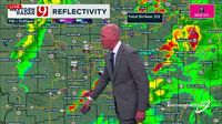
KOCO 5 Chief Meteorologist Damon Lane noted that storms were still developing, and the longer they took to form, the lower the tornado risk became. Lane indicated that storms would likely develop after 8 p.m., with hail and heavy rain being the main concerns.
By 3:35 p.m. on Friday, Lane had identified the area with the greatest threat for severe storms, which included Lawton, Chickasha, Pauls Valley, Ada, Seminole, Okmulgee, and areas south of the Oklahoma City metro, including Norman. The greatest threat for Friday night was anticipated to be baseball-sized hail and possibly a tornado or two.
As the day progressed, a flood watch was issued until 7 p.m. on Sunday for several counties, including Kay, Garfield, Noble, Kingfisher, Logan, Payne, Caddo, Canadian, Oklahoma, Lincoln, Grady, McClain, Cleveland, Pottawatomie, Seminole, Hughes, Tillman, Comanche, Stephens, Garvin, Murray, Pontotoc, Coal, Cotton, Jefferson, Carter, Johnston, Love, Osage, Washington, Nowata, Craig, Ottawa, Pawnee, Tulsa, Rogers, Mayes, Delaware, Creek, Okfuskee, Okmulgee, Wagoner, Cherokee, Adair, Muskogee, McIntosh, Sequoyah, Pittsburg, Haskell, Latimer, and Le Flore.
As the storms moved into the Oklahoma City metro area, the News 9 Weather Team reported tracking storms and noted that severe thunderstorm warnings had been issued for multiple counties. At 12:45 a.m., Tracker Hank Brown reported a jack-knifed semi-truck on westbound I-44 near Penn Square Mall, prompting the Highway Patrol to shut down all of I-44 in that area.
In Northeast Oklahoma City, Val and Amy Castor reported that rain was beginning to pick up at 12:20 a.m. As of 11:30 p.m. on Friday, multiple counties were under severe thunderstorm watches and warnings, although no tornado warnings were in effect at that time. By 9:30 p.m., golf ball-sized hail had been reported moving into Wynnewood.
As the storms continued to develop and move across the state, residents were urged to stay alert and monitor local weather updates for the latest information and safety instructions.