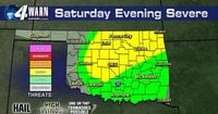
Severe thunderstorms swept through northern and central Oklahoma on Saturday night, March 29, 2025, leaving a path of destruction and prompting multiple warnings from the National Weather Service. The storms, which began developing after 7 PM, were fueled by the intersection of a dryline and a cold front in northern Oklahoma, leading to explosive storm activity, particularly from the north Oklahoma City metro area to the Kansas state line.
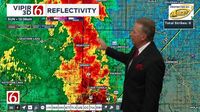
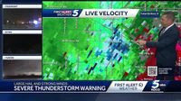
As the evening progressed, meteorologists warned of significant threats, including very large hail and strong winds. According to KOCO 5 Chief Meteorologist Damon Lane, the storms could produce hail the size of golf balls and winds exceeding 70 miles per hour. "It's an active period," Lane noted, emphasizing the potential for severe weather as the system moved eastward.
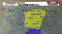
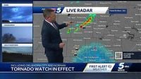
By 7:50 PM, the National Weather Service had issued a tornado watch for a large portion of Oklahoma, which remained in effect until 1 AM on Sunday. This watch included numerous counties such as Atoka, Blaine, Bryan, Caddo, Canadian, and many others, covering a vast area of the state.
As the storms intensified, severe thunderstorm warnings were rapidly issued for several counties, including southwestern Lincoln County, Oklahoma County, and northeastern Cleveland County, with warnings set to expire around midnight. The primary threats associated with these storms were wind gusts up to 60 mph and hail ranging from quarter-sized to golf ball-sized.
Reports from the Oklahoma Gas and Electric Company indicated that by early Sunday morning, over 2,300 customers were without power due to the storms. The highest number of outages was reported in Shawnee, where 1,640 customers lost power, with El Reno following closely behind with over 420 outages.
As the night wore on, the severe weather threat transitioned into eastern Oklahoma. By 1 AM on Sunday, March 30, 2025, heavy thunderstorms had moved through counties including Mayes, Rogers, Tulsa, and Wagoner, prompting additional severe thunderstorm warnings.
The storms were characterized by heavy downpours and strong winds, with reports of power outages continuing to rise. In Osage County, more than 240 customers experienced outages, while warnings were issued for Craig, Nowata, Rogers, and Washington counties until 1:45 AM.
These storms were part of a larger weather system affecting the Midwest, with the Storm Prediction Center indicating that severe weather could extend into the Ohio and Tennessee River valleys on Sunday. Areas such as northern Louisiana, Arkansas, and parts of Kentucky and Indiana were also under enhanced risk for severe storms, with forecasters warning that all severe hazards, including large hail and tornadoes, were possible.
As forecasters continued to monitor the situation, they advised residents to remain vigilant and prepared for further developments. The severe weather threat was expected to taper off by Sunday morning as a cold front moved through the region.
In summary, the severe thunderstorms that impacted Oklahoma on Saturday night brought significant weather challenges, including large hail, strong winds, and power outages. Residents were urged to stay informed and heed any weather warnings as the storm system continued to evolve.