As the weekend approaches, a significant shift in weather patterns is set to impact much of France, bringing with it thunderstorms, hail, and fluctuations in temperature. Starting Friday, May 9, 2025, a cold drop positioned over the near Atlantic is expected to create unstable weather conditions across the country.
On Friday, showers are anticipated around the massifs and towards the northwest of France. These will include locally stormy weather circulating between Limousin and Brittany, with maximum temperatures hovering around 20 degrees Celsius. The day will see a mix of sun and clouds, but the calm will be short-lived.
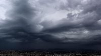
By Saturday, May 10, the situation will deteriorate as the wind strengthens, pushing maritime entries across the southern regions. Morning rains will affect areas from Aude to Lozère, while the afternoon will see the development of thunderstorms, particularly in the South-West. These storms are expected to be more significant than those of the previous day, with hail and wind gusts reaching up to 90 km/h.
According to Météo France, "the atmosphere will be humid and heavy" with temperatures rising to 23 degrees Celsius in Paris and Bordeaux, while cities like Marseille and Nice will remain slightly cooler at around 20 degrees Celsius. As the day progresses, up to 40 mm of rain could accumulate between the Basque Country and Bordeaux, equivalent to about two weeks of rain for this time of year.
Sunday, May 11, will bring even more intense weather, as a frontal system organizes rains that will progress slowly from the Atlantic. Météo France warns that accumulations of 30 to 40 mm are possible in the plains between Midi-Toulousain and Auvergne, with some areas in the Languedoc back country potentially receiving 50 to 70 mm. Temperatures are expected to drop below 20 degrees Celsius in the South-West.
As the new week begins, the front will stretch across regions from the Alps to Bourgogne-Franche-Comté and the Bay of Somme, bringing further instability and the possibility of additional thunderstorms. Monday and Tuesday are predicted to continue this trend, with temperatures remaining slightly below normal.
In light of these forecasts, Météo France has placed several departments under yellow vigilance for thunderstorms, including Charente and Charente-Maritime. From noon on Saturday, May 10, these areas will experience storms accompanied by strong rain and hail, with gusts reaching up to 90 km/h expected.
Emmanuel Moreau, a meteorologist from Ici La Rochelle, noted that while thunderstorms are forecasted to begin in the early afternoon, the most intense activity will occur later in the day, particularly between 5 p.m. and 6 p.m. He cautioned that while some forecasts suggest a red alert, this may be an exaggeration, as the expected rainfall accumulations are likely to be localized.
In the Charente region, strong accumulations of rain could reach up to 60 mm, with hailstones potentially measuring 2 to 3 centimeters, which could damage crops and vehicles. The local authorities are ramping up their readiness with additional agents on standby in case of road issues.
As the storms roll through, residents are urged to take precautions. Météo France advises people to stay away from trees and bodies of water, seek shelter in sturdy buildings, and avoid travel during severe weather. Protecting vulnerable property from wind and flooding is also recommended.
Looking ahead, the weather is expected to stabilize after the stormy weekend, with calmer and clearer conditions anticipated for the following week. However, forecasters have warned that the beginning of the Saints de Glace, a climatological period known for potential frost, could still bring a risk of cold snaps.
Overall, this weekend's weather is a stark reminder of the unpredictable nature of spring in France. Residents are encouraged to stay informed through Météo France updates and to adapt their plans accordingly to ensure safety during this tumultuous weather period.