On the evening of September 25, 2025, residents across several states in the eastern United States found themselves under siege from rapidly developing severe thunderstorms, as warnings from the National Weather Service (NWS) swept through North Carolina, South Carolina, and Pennsylvania. These storms, known for their sudden intensity, brought not only strong winds and hail but also a flurry of urgent safety advisories and practical tips for staying safe in the face of nature’s fury.
In central North Carolina, the NWS office in Raleigh issued a series of severe thunderstorm warnings that evolved throughout the evening. According to WNCN, the first alert was dispatched at 6:17 p.m., covering all of Johnston County and the southeastern part of Wake County, with an expiration set for 7 p.m. As the situation changed, the warning was adjusted around 6:40 p.m. to drop Wake County and instead include east central Harnett County, still set to expire at 7 p.m. But the atmosphere had other plans. By 7:14 p.m., the NWS renewed warnings specifically for southern Johnston County—including Smithfield, Selma, and Benson—where a storm was spotted over Benson, barreling east at 25 miles per hour and packing the potential for 60-mile-per-hour winds and quarter-sized hail.
Just minutes later, at 7:35 p.m., the NWS Raleigh delivered an updated warning for Johnston County. The storm, now near Smithfield and moving northeast at the same steady 25 mph, was forecast to bring penny-sized hail (about 0.75 inches) and wind gusts up to 60 mph, as reported by local news outlets. The advisory specifically mentioned Smithfield, Selma, Four Oaks, and Pine Level as areas at risk. The NWS cautioned, “For your protection move to an interior room on the lowest floor of a building,” and warned that “damage to roofs, siding, and trees” was possible. These warnings were set to remain in effect until 8 p.m.
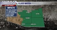
Further south, the NWS office in Greenville-Spartanburg, South Carolina, was also tracking dangerous conditions. At 6:55 p.m., a severe thunderstorm warning was issued for Spartanburg County and neighboring counties—Cleveland, Rutherford, and Cherokee—effective until 8 p.m. The NWS described the threat in stark terms: “At 6:54 p.m. EDT, a severe thunderstorm was located 11 miles north of Spartanburg, or 4 miles north of Boiling Springs SC, moving east at 30 mph. HAZARD: 60 mph wind gusts and penny size hail. SOURCE: Radar indicated. IMPACT: Expect damage to trees and power lines.” Areas including Gaffney, Boiling Springs (both in South Carolina and North Carolina), Inman, Blacksburg, Mayo, Chesnee, Campobello, Lattimore, and Mooresboro were all listed as being in the storm’s path. The NWS urged those in the area to seek shelter in an interior room on the lowest floor and to report any damage via phone or social media.
Meanwhile, in Pennsylvania, the NWS issued a severe thunderstorm warning for central York County and southwestern Lancaster County. The storm, located over West York, was racing eastward at about 40 miles per hour and was expected to bring with it 60 mph wind gusts and torrential rainfall, raising the specter of flash flooding. The warning covered York, Weigelstown, Red Lion, Spry, Dallastown, Shiloh, and East York, and was set to expire at 4:45 p.m.
With millions of Americans under threat from these storms, the NWS and local authorities provided a host of safety recommendations designed to keep people out of harm’s way. According to the NWS, lightning strikes the United States about 25 million times each year, with most incidents occurring during the summer months and causing around 20 fatalities annually. As thunderstorms approach, the risk of lightning increases, peaking when the storm is overhead. The NWS advises that if you can hear thunder, you are already within striking distance and should seek shelter immediately. Their oft-repeated mantra: “When thunder roars, go indoors.”
Once inside, the NWS recommends steering clear of corded phones, electrical devices, plumbing, and windows or doors. It’s best to wait at least 30 minutes after the last thunderclap before venturing outside again. For those caught outdoors, the advice is to avoid open fields, hilltops, isolated trees, and water. If you’re in a group, spread out to reduce the risk of multiple injuries from a single strike. And don’t be fooled—tents offer no protection from lightning.
Driving in these conditions presents its own challenges. Headlights should always be on, even in daylight, to improve visibility. Drivers are urged to stick to middle lanes, avoid puddles (which can cause hydroplaning or loss of control), and steer clear of flooded roads entirely. As the NWS points out, “The strong currents from flash floods can pull drivers off roadways. Driving through deep water can also negatively affect a vehicle’s mechanical and electrical systems.”
Hydroplaning is a particular hazard during heavy rain. It occurs when a vehicle’s tires lose contact with the road surface and ride on a thin layer of water, causing a dangerous loss of control. The NWS highlights three main contributors: vehicle speed, water depth, and tire tread depth. To avoid hydroplaning, reduce your speed, ensure your tires are in good shape, and avoid driving through standing water. If your vehicle does start to hydroplane, ease off the accelerator, steer into the skid, and wait for the tires to regain traction before gently straightening out—brake gently, especially if your car lacks anti-lock brakes.
For those in the direct path of Thursday’s storms, the advice was clear and urgent. The NWS in Greenville-Spartanburg stated, “For your protection move to an interior room on the lowest floor of a building.” They also encouraged residents to report any incidents of damaging winds, hail, or flooding, providing multiple ways to contact the agency, including a toll-free number and social media channels.
Pets and property were not forgotten in the flurry of warnings. The NWS recommended bringing pets inside and securing loose outdoor objects, which could become dangerous projectiles in high winds. If time allowed, checking fences was advised to prevent pets from escaping during the chaos.
As the storms barreled through, residents from North Carolina to Pennsylvania were reminded of the power and unpredictability of severe weather. With warnings delivered in real time and practical safety advice from the NWS and local media outlets, many communities were able to prepare and respond quickly, minimizing the risk to life and property.
These events underscore the importance of staying alert to weather warnings and knowing exactly what to do when severe storms threaten. Quick action and adherence to expert guidance can make all the difference when the skies turn dark and the winds begin to howl.