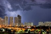
Severe thunderstorms rolled through South Florida on March 17, 2025, prompting officials to issue tornado and severe thunderstorm warnings for several areas, including South Palm Beach County. Although the immediate threats have now diminished, the volatile weather faced by local residents started early Monday morning, leading to significant concerns over public safety.
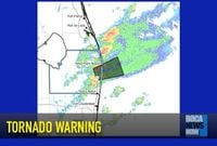
At 6:19 AM EDT, the National Weather Service (NWS) issued a Tornado Warning for east central Palm Beach County, cautioning residents to seek shelter immediately. A severe thunderstorm capable of producing tornadoes was detected over Lake Worth and was moving east at 30 mph. The warning was expected to remain effective until 6:45 AM. The NWS described the potential impacts as quite severe, anticipating damage to mobile homes, roofs, and vehicles, as well as likely tree damage. Areas such as Boynton Beach, Palm Beach International Airport, and the Lake Worth Corridor were all included in the warning.
Just prior to this alert, another severe weather warning was activated at 6:13 AM for eastern Palm Beach County. Weather radar indicated severe thunderstorms along a line extending from Lake Belvedere Estates to Kings Point, forecasted to move eastward at 40 mph with expected wind gusts of up to 60 mph. Locations including Glades, Greenacres, and the Port of Palm Beach were warned of the possibility of extensive damage.
By 6:42 AM, reports confirmed both warnings had expired, giving way to clearer skies. The storms were characterized by heavy rainfall, though only minor reports of damage came through from the affected regions. Residents were urged to remain cautious, as heavy rains can sometimes obscure the formation of tornadoes.
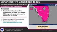
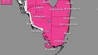
Beyond the immediate risk of severe weather, South Florida faced elevated fire risks later on the same day. A Red Flag Warning was issued from noon until 8 PM, impacting Miami-Dade, Broward, Monroe, and Palm Beach counties. The National Weather Service warned of gusty northwesterly winds combined with low humidity levels forecasted to drop below 30%, which could lead to increased fire spread. Given the state's recent weather, the potential for wildfires became a pressing concern, effectively turning the attention from severe storm dangers to fire hazards.
With temps expected to drop on the night of March 17 to the mid-50s—about 10 degrees cooler than the usual March weather—they anticipated warmer days would follow. The following day, March 18, was projected to see sunny conditions return, with highs around 77°F and low humidity, making for a quick transition from the severe storms of the previous day.
This relentless weather pattern was part of a broader trend affecting the region following severe storms and numerous tornadoes across states, which resulted unfortunately in at least 40 fatalities over the weekend. Victims were reported across seven states, showcasing the severe impact of weather systems sweeping through the central and southern U.S.
Notably, more than 50 tornadoes were reported during the event, and widespread flooding affected various structures and landscapes. Florida, largely spared the brunt of these storms, still remained vigilant due to forecasts predicting high winds and waterspouts affecting areas like St. Augustine and southeast coastal regions.
Looking beyond immediate forecasts, Tuesday and Wednesday were expected to bring sunny skies with temperatures gradually rising, reaching the upper 70s to low 80s through the latter part of the week. For residents, this stark shift from stormy to sunny weather might bring some reprieve after what was considered tumultuous early conditions.
Weather officials have emphasized the importance of preparation during such volatile times. The guidance on participating safely amid fire warnings included avoiding outdoor burning practices and being diligent about common fire hazards such as discarded cigarettes, which can ignite dry grasses and lead to dangerous wildfires.
The variable and unpredictable weather patterns seen currently serve as reminders of the volatile nature of climate conditions and the need for continued vigilance as the region transitions from stormy showers to more stable conditions.