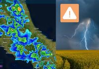
On Wednesday, April 23, 2025, intense and sudden rains are sweeping through the inland areas of the Marche region in Italy, causing significant concern among residents and local authorities. The weather had been predicted with a yellow alert from the Civil Protection for thunderstorms across the region, and the forecasts proved accurate as heavy downpours began around midday.
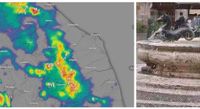
In Caldarola, a town in the Macerata area, the situation escalated quickly when 12.2 mm of rain fell in just 15 minutes starting at 3 PM. This was not an isolated incident, as other areas also experienced intense rainfall. Fabriano city and Monte San Vicino recorded about 20 mm of rain within a mere two hours, beginning at the same time. Similarly, Frontone and Monte Nerone saw approximately 15 mm of rain in just half an hour shortly after 1 PM. These sudden downpours have raised alarms about potential flooding and other weather-related hazards.
Adding to the tumultuous weather, hail was reported in the Ascoli area, marking the beginning of a challenging weather pattern for the region. These severe weather conditions are expected to worsen as the week progresses, with forecasters predicting even more intense storms leading into April 25.
The phenomenon of supercells, which are the most dangerous type of thunderstorms known for their immense height and potential for destruction, is becoming a focal point for meteorologists. These towering storm systems can reach heights of 10 to 12 kilometers and are characterized by a rotating area of low pressure called a mesocyclone. As temperatures rise in spring and summer, the atmospheric conditions become ripe for these storms to develop, bringing with them the risk of extreme weather events such as hail and, in rare cases, tornadoes.
On the same day, meteorologists warned that the arrival of a cold front would destabilize the atmosphere, leading to the formation of thunderstorms particularly in northern regions. Between the evening and night of April 23, regions such as Piedmont and Lombardy are expected to face heavy rainfall, with forecasts indicating that over 50 mm of rain could fall in a short time. This is particularly concerning as these regions will be in a convergence zone, where different air masses interact, increasing the likelihood of supercell formation.
As the storm front moves southward, it will reach the Veneto and Friuli Venezia Giulia regions, where violent storms are also anticipated. The Civil Protection has issued a yellow alert for thunderstorms across 11 regions, including Lombardy, Emilia Romagna, Tuscany, Marche, Abruzzo, Umbria, Lazio, Molise, Puglia, Basilicata, Calabria, and Sicily.
Looking ahead, the weather forecast for April 25 indicates a continuation of this unstable weather pattern, with a disturbance expected to affect Triveneto, Emilia Romagna, and Marche from the morning. The afternoon will see an increase in instability across the central regions and the southern Apennines, where thunderstorms of strong intensity are likely. Temperatures are also expected to drop in the Apennines and the Adriatic regions, leading to a cooler and more unpredictable climate.
As for the weekend, forecasts show another unstable weather impulse affecting primarily Piedmont, Valle d'Aosta, and Liguria on Saturday, April 26. The instability is expected to spread to the entire Alpine arc, Tuscany, and the internal areas of Lazio, Abruzzo, and Molise, where thunderstorms and heavy showers could develop. By Sunday, April 27, conditions will remain unstable, particularly in the afternoon, with thunderstorms likely in central Italy's internal regions and throughout the Apennines.
Local residents are advised to remain vigilant and prepared for rapidly changing weather conditions, as the potential for severe storms and related hazards continues to loom over the region.